← Explore the cityBRATSK / PEOPLE & PLACES

The largest towns and villages of Bratsk District.

Vikhorevka, Pokosnoye, Pribrezhny, Turma and other major communities. A historical population ranking from the 2010 census, profiles of twenty places and a separate top five of villages classified as derevnya. Later figures appear separately.

23 CHAPTERS / ABOUT 8 MIN READ
2010

One census year throughout the ranking

20

Largest places in the table

59

Individual places checked against the source

825

Residents in Kuvatka, the largest derevnya in 2010

Top twenty in the 2010 census

The largest towns and villages of Bratsk District / 2010
PlaceTypeResidents, 2010
01. Vikhorevka ↘Town22,520
02. Pokosnoye ↘Village (selo)2,998
03. Pribrezhny ↘Settlement2,555
04. Turma ↘Settlement2,019
05. Tangui ↘Village (selo)1,883
06. Kaltuk ↘Village (selo)1,789
07. Kezhemsky ↘Settlement1,651
08. Klyuchi-Bulak ↘Village (selo)1,387
09. Kharanzhino ↘Settlement1,298
10. Ilir ↘Village (selo)1,158
11. Kuznetsovka ↘Village (selo)1,113
12. Bolsheokinskoye ↘Village (selo)1,105
13. Dobchur ↘Settlement1,069
14. Tarma ↘Settlement1,039
15. Kuvatka ↘Village (derevnya)825
16. Koblyakovo ↘Village (selo)788
17. Ozerny ↘Settlement681
18. Priboyny ↘Settlement674
19. Tem ↘Village (selo)666
20. Shumilovo ↘Settlement649

Source: Irkutskstat, 2010 census results; bulletin published in 2012. Open the original table ↗

Article contents

Vikhorevka: the district’s only town

With 22,520 residents in the 2010 census, Vikhorevka led by a considerable margin. It is the only town within Bratsk District. A railway station established in 1947 grew into depots, residential streets and public institutions; town status followed in 1966.

It accounted for approximately 39.6 percent of district residents in this census snapshot, helping explain its transport and service role. Later population figures appear separately below, preserving one consistent date within the ranking.
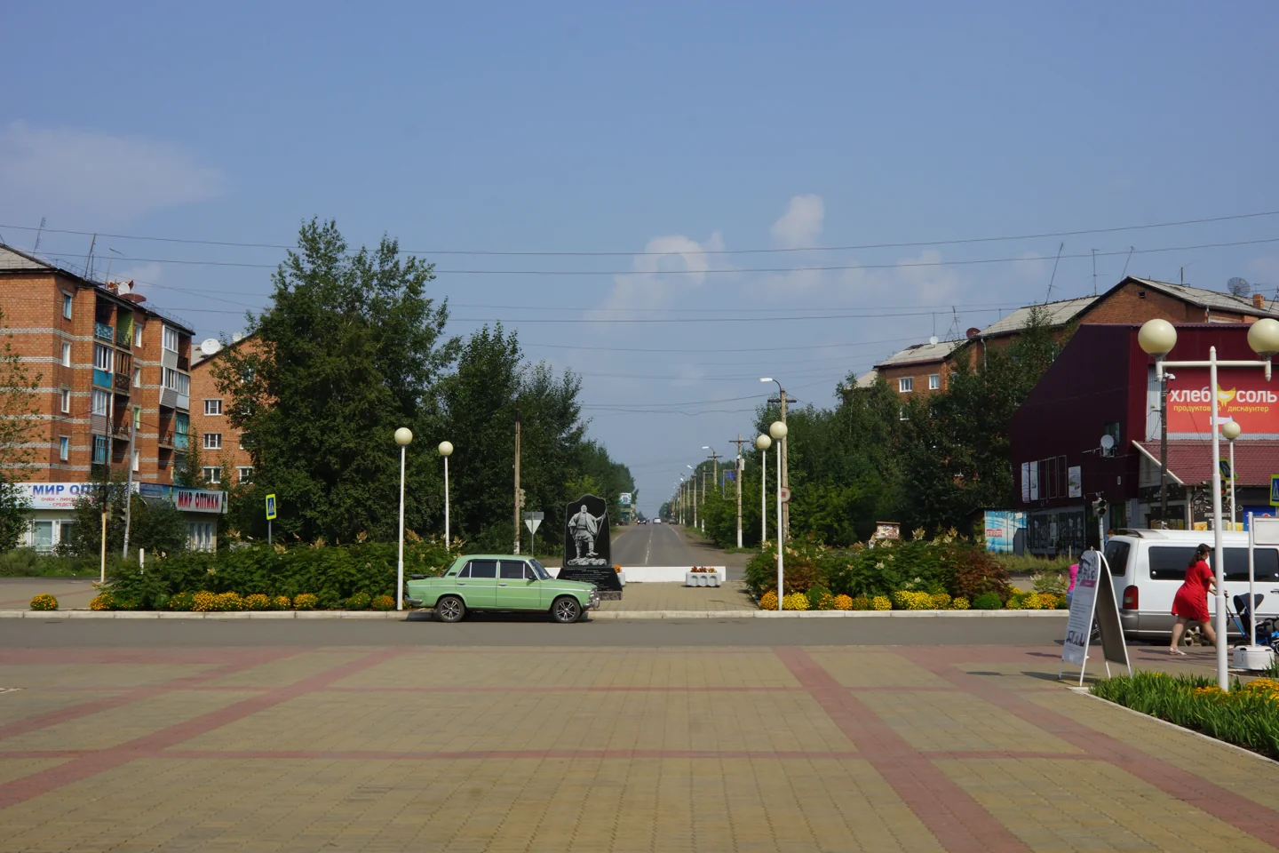
13 August 2020. Looking from the station square towards Lenin Street. Vikhorevka is a town within Bratsk District; the photograph shows its modern urban setting.
2020

Vikhorevka station square

13 August 2020. Looking from the station square towards Lenin Street. Vikhorevka is a town within Bratsk District; the photograph shows its modern urban setting.

Vasily Astanin · Wikimedia Commons · уменьшено, WebP / resized, WebP
CC BY-SA 4.0 · Original ↗
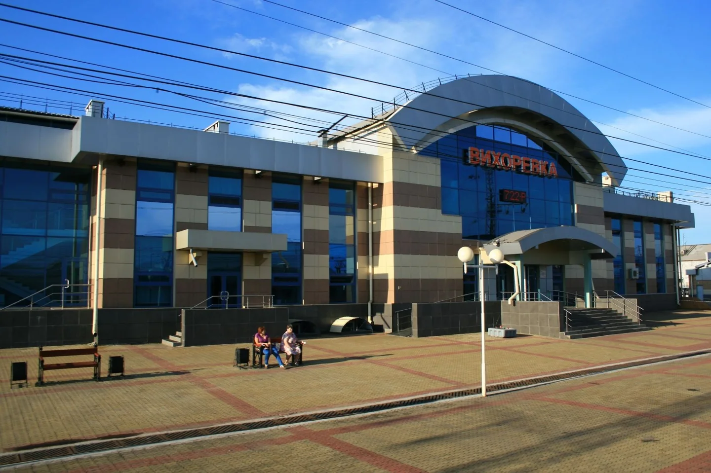
Vikhorevka station in an author-contributed Wikimedia Commons photograph. The file page gives 2018; this is a modern view rather than a railway-construction photograph.
2018 · источник / source

Vikhorevka railway station

Vikhorevka station in an author-contributed Wikimedia Commons photograph. The file page gives 2018; this is a modern view rather than a railway-construction photograph.

4ikish · Wikimedia Commons · уменьшено, WebP / resized, WebP
CC BY-SA 4.0 · Original ↗
Pokosnoye: the largest selo in the 2010 census

Pokosnoye’s 2,998 residents placed it second overall and first among places classified as selo in 2010. The village itself differs from Pokosnoye rural municipality, which contained 3,292 people including Sosnovy. Only the village population enters this ranking.

Agriculture, education, a cultural centre and music teaching shaped its community life. The cultural centre’s history records Iosif Kobzon visiting during a trip to dam and power-line builders. Pokosnoye illustrates a rural centre whose significance extended beyond agricultural production.

Pribrezhny: the largest posyolok in this census snapshot

Pribrezhny had 2,555 residents, ranking third overall and first among places classified as posyolok. The larger Pribrezhny rural municipality counted 2,975 people across several communities. The figures describe different territories.

The census lists Bulak, Novoye Prirechye and Chistyakovo alongside Pribrezhny, the grouping’s centre. District history records television-relay development in the 1980s, while a local cultural centre supports community life. Despite the term posyolok, its population is classified as rural in this table.

Turma: a substantial railway settlement

Turma’s 2,019 residents placed it fourth in 2010. Its rural municipality contained one settlement in this census snapshot, so the municipal and individual-place totals coincide. That relationship should not be assumed for municipalities containing several communities.

Turma belongs to the district’s railway geography. The administration’s transport programme lists its station alongside Vikhorevka, Zyaba and Kezhemskaya. Local institutions and connections with the surrounding countryside complement the railway role. Turma is a separate district settlement outside Bratsk city.

Tangui: a village that once administered a district

Tangui ranked fifth with 1,883 residents. Tangui rural municipality counted 3,388 people, including Alexandrovka, Bada, Vorobyovo, Zarb and Khudobok. The larger municipal total should not be used as the population of the village itself.

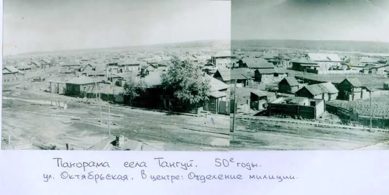
Tangui served as a separate district centre in 1935–1959. Reservoir creation required residents to establish a new site. Museum material documents the old village, relocation and school construction. Archival and modern panoramas depict different locations connected by the same name.

Archival panorama identified as Tangui in the 1950s in the municipal publication. Timber buildings and a village street are visible. Old and new Tangui occupy different sites.
1950-е · 1950s

Panorama of old Tangui

Archival panorama identified as Tangui in the 1950s in the municipal publication. Timber buildings and a village street are visible. Old and new Tangui occupy different sites.

Автор не указан / photographer not identified · Музей с. Тангуй / администрация Братского района
© правообладателя / rights reserved · Original ↗

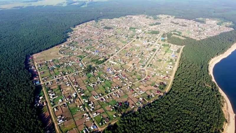
2022, according to the source caption. The relocated village has streets, homesteads, forest and a reservoir shore. It is not a repeat view from the same position as the old Tangui panorama.
2022

New Tangui from above

2022, according to the source caption. The relocated village has streets, homesteads, forest and a reservoir shore. It is not a repeat view from the same position as the old Tangui panorama.

Автор не указан / photographer not identified · Музей с. Тангуй / администрация Братского района
© правообладателя / rights reserved · Original ↗

Kaltuk: farming, medical services and a new shoreline

Kaltuk ranked sixth with 1,789 people. Its municipality total was 1,792 because Cheremshanka was recorded separately. The difference is small, but the ranking consistently uses the village’s own row.

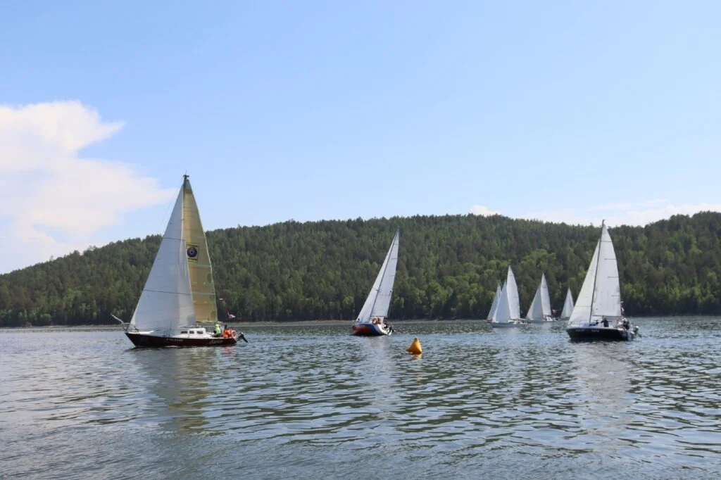
Kaltuk’s history combines agriculture with residents relocated from Malaya and Bolshaya Kada. Its local account describes a hospital receiving patients in June 1961 and serving neighbouring communities. Contemporary Kaltuk also hosts water-based sport, including a sailing regatta dedicated to the district centenary in 2026.

Yachts on the reservoir in the June 2026 report on Kaltuk’s third regatta, dedicated to Bratsk District’s centenary.
2026

A sailing regatta near Kaltuk

Yachts on the reservoir in the June 2026 report on Kaltuk’s third regatta, dedicated to Bratsk District’s centenary.

Фотограф не указан / Photographer not identified · Администрация Братского района / Bratsk District administration
© правообладателя / rights reserved · Original ↗

Kezhemsky: the settlement and its wider municipality

Kezhemsky ranked seventh with 1,651 residents. The wider Kezhemsky rural municipality counted 2,218, including 567 in Mamyr. The difference demonstrates why a municipal total cannot automatically be assigned to its administrative centre.

The settlement forms part of the district’s taiga transport and production network, with schools, cultural activity and local administration alongside its economic history. Its exact name and district matter when researching it, since similarly named places elsewhere in Siberia have distinct histories.

Klyuchi-Bulak: a rural centre and meeting place for musicians

Klyuchi-Bulak occupied eighth place with 1,387 residents. Its municipality contained 2,301 people including Kumeyka and Leonova; the ranking uses only the village figure.

Klyuchi-Bulak combines an agricultural past with a contemporary cultural role. The Vertikal singer-songwriter festival held its fourth edition here in July 2026. Bringing people together from different district communities, the event gives this rural centre visibility beyond its administrative grouping.

Kharanzhino: a substantial outlying settlement

Kharanzhino ranked ninth with 1,298 people in 2010. Its municipality total was 1,462, with Oktyabrsk and Tukovsky listed separately. These are different levels of statistical observation.

District documents discuss transport, utilities, education and communications here; the chronicle records a television relay in the 1980s. Reliable connections and public institutions matter particularly in outlying communities. A population figure alone cannot convey the distances and practical conditions of everyday life.

Ilir: an important rural service centre

Ilir ranked tenth with 1,158 residents. Its municipality, including Karay, Kardoy and Lugovoy, counted 1,691: more than five hundred people lived outside Ilir itself.

The village’s history connects the Iya valley with agriculture. Its cultural centre remains a community institution, preparing a photographic history exhibition for the district centenary. Ilir illustrates how a rural centre combines economic activity, education, performance and the memory of several neighbouring communities.

Kuznetsovka: from a smallholding to an established rural centre

Kuznetsovka ranked eleventh with 1,113 people. The municipality contained 1,132 including Bambuy, whose population is counted separately.

The local gazetteer traces the place to a recorded Kuznetsov smallholding in 1863. Subsequent growth involved an agricultural enterprise producing milk, grain and vegetables, alongside schools, a library and cultural institutions. An established rural centre developed from a much smaller original settlement.

Bolsheokinskoye: Oka farming history and resettlement

Bolsheokinskoye ranked twelfth with 1,105 residents. Its municipality total of 1,609 included Novodolonovo, so almost one-third of the wider population lived outside the village itself.

Its history connects farming with the shoreline changes brought by the reservoir. The Faces of Flooded Villages project recorded residents recalling old Bolsheokinsk and Dolonovo. Understanding the rural centre therefore also involves the earlier places from which families relocated.

Dobchur: a settlement connected with a ferry crossing

Dobchur ranked thirteenth with 1,069 residents. The municipality counted 1,070 in 2010, with one additional person recorded in Khakharey. The ranking uses Dobchur’s own figure.

Transport history connects the settlement with the district’s water geography. The administration’s 2022 report specifically names the Dobchur ferry crossing. Its role illustrates why settlement size benefits from consideration alongside accessibility. Current crossing arrangements require recent carrier information rather than historical operating reports.

Tarma: a temporary logging settlement became permanent

Tarma ranked fourteenth with 1,039 people; settlement and municipal totals coincide in the census table. Its growth involved reservoir-bed preparation, resettlement and the timber enterprise.

The official history describes an initial plan for a temporary community lasting about five years. The first houses appeared in summer 1961, with arrivals from Yelanka, Dolonovo, Dunayka and elsewhere. Permanent work and family settlement gave the short-term project a much longer life.

Kuvatka: the largest place classified as derevnya

Kuvatka ranked fifteenth overall with 825 residents and was the largest district place officially classified as derevnya in this census. Its municipal and village totals coincide.

Everyday language often uses “village” for several Russian settlement types, but the table distinguishes derevnya from selo and posyolok. Pokosnoye and Kaltuk are classified as selo. Kuvatka also connects with resettlement history: the flooded-villages documentary project preserves memories of old Kuvatka, adding personal experiences to the statistical record.

Koblyakovo: a rural centre with several historical layers

Koblyakovo ranked sixteenth with 788 residents. Its municipality counted 1,659 including Anchirikovo, Burninskaya Vikhorya, Dubynino, Pridorozhny and Sakhorovo, more than twice the centre’s own population.

Koblyakovo’s history includes older farmsteads, a machine-and-tractor station, a state farm and public institutions. Local accounts recall Ivan Naymushin assisting after a fire and the construction of new homes. Surviving photographs reveal older timber buildings alongside later rural development.

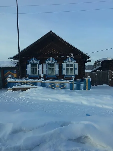
A wooden house identified in the local-history publication as standing in the old part of Koblyakovo. The owner and photograph date are not supplied.
б/д · undated

A house in old Koblyakovo

A wooden house identified in the local-history publication as standing in the old part of Koblyakovo. The owner and photograph date are not supplied.

Фотограф не указан / Photographer not identified · Журнал «Прибайкалье» / Pribaikalye magazine
© правообладателя / rights reserved · Original ↗

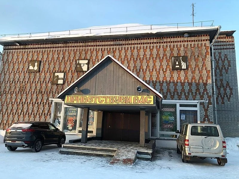
The source identifies this as the Koblyakovo club built in 1985. The photograph is undated; 1985 refers to the building.
б/д · undated

Kolos cultural centre in Koblyakovo

The source identifies this as the Koblyakovo club built in 1985. The photograph is undated; 1985 refers to the building.

Фотограф не указан / Photographer not identified · Журнал «Прибайкалье» / Pribaikalye magazine
© правообладателя / rights reserved · Original ↗

Ozerny: a distinct community behind a water-related name

Ozerny ranked seventeenth with 681 people. Its municipality counted 685 including Pervomaysky. Even this small difference reflects separate census rows for individual places.

Ozerny belongs to the district’s network of rural centres, with its own administration and access conditions. Searches should specify Bratsk District because the same name occurs elsewhere in Russia. The name alone does not establish proximity to a particular beach or an available approach route.

Priboyny: a smaller centre within the top twenty

Priboyny occupied eighteenth place with 674 residents. Its municipality total was 701 including Chisty; the comparison uses Priboyny’s separate figure.

Municipal records identify it as an independent rural centre, with community life involving local institutions, utilities and connections with other parts of the district. Its position illustrates the district’s settlement scale: a place with several hundred residents already appears among the twenty largest.

Tem: an old village shaped by relocation

Tem ranked nineteenth with 666 residents. Its municipality contained 853 including Barchim, a different territorial total from the village itself.

Tem combines a long Angara history with relocation during reservoir creation. Old Tem appears in the flooded-villages oral-history project. The regional bibliography also records Tem: From the Past into the Future, providing further reading alongside documents, photographs and the work of the village library.

Shumilovo: completing the top twenty

Shumilovo completes the top twenty with 649 residents in 2010. Its rural municipality consisted of one settlement, so both totals coincide.

An older district economic account mentions Shumilovo’s shipyard; such references require attention to their date and the Angara’s changing geography. The ranking also reveals a broader pattern: the district consists predominantly of small communities. Another thirty-nine census entries remain outside the top twenty, including very small villages and places without permanent residents.

The largest villages classified specifically as derevnya

Filtering the 2010 census to places classified specifically as derevnya produces this top five: Kuvatka, 825; Leonova, 474; Kumeyka, 440; Khudobok, 439; and Kardoy, 366. This is a separate comparison within one rural category.

Leonova and Kumeyka belong to the Klyuchi-Bulak grouping, Khudobok to Tangui’s and Kardoy to Ilir’s. Kumeyka and Khudobok differed by just one resident. The date is essential: that tiny difference cannot establish their relative size throughout every subsequent year.

What later figures establish

Newer figures exist, but not always at the same geographical level. Irkutskstat’s published 2021 census table records 21,719 people in Vikhorevka, while many rural rows describe whole municipalities. For example, Kaltuk rural municipality’s 1,526 residents cannot automatically be assigned to Kaltuk village alone.

The district profile gives 21,092 urban residents, all in its sole town Vikhorevka, and 46,584 district residents overall for 1 January 2025. These provide later context. Keeping them outside the 2010 table prevents a recent town estimate being presented beside old village figures as a single contemporary ranking.

How the list was compiled and why Bratsk is absent

The ranking uses Irkutskstat’s official 2010 census bulletin, published in 2012. Bratsk District appears on printed pages 12–13, corresponding to PDF pages 13–14. All fifty-nine individual places were extracted; their combined 56,878 residents reconcile with the published district total. Sorting those rows by population produces the top twenty. Modern photographs and historical accounts accompany this explicitly dated statistical snapshot.

The measure is permanent residents, rather than area or local importance. Bratsk administers the district but forms a separate urban municipality and is excluded. Individual communities are also distinguished from municipal groupings containing several places. The table describes 2010; a complete update requires a newer comparable dataset at individual-settlement level.

Useful links

Bratsk District: a history of the wider Angara country ↗Neighbourhoods within Bratsk city ↗Bratsk Reservoir ↗

Sources & further reading

Checked 19 October 2026. The ranking uses the 2010 census and is not presented as a current 2026 ranking. The bulletin was published in 2012. Later 2021 and 2025 figures are discussed separately. Settlement types follow the census source; photographs retain their own dates.