← Explore the cityBRATSK / PEOPLE & PLACES

Bratsk District: a history of the wider Angara country.

A district centenary within millennia of local history: Vikhorevka, fifty-eight rural communities, flooded villages, railways, logging settlements, farming and new shorelines. An extensive guide to the territory beyond Bratsk city.

The largest towns and villages of Bratsk District ↗
47 CHAPTERS / ABOUT 26 MIN READ
1926

28 June: the district’s accepted founding date

32 531

Square kilometres in the district profile

59

Inhabited places in the official list

46 584

Residents on 1 January 2025

Article contents

Bratsk District: the wider world beyond the city

Bratsk District is a separate territory of Irkutsk Oblast, with its own rural history, the town of Vikhorevka and dozens of settlements. Bratsk is its administrative centre but does not belong to the district: the city forms a separate municipality. Energetik, Padun and the Central district therefore occupy a different administrative category from Tangui, Ilir and Tarma.

For visitors, these places remain closely connected, and Bratsk provides a useful starting point for exploring the surrounding Angara country. The district’s history, however, extends far beyond the industrial city. Farming villages, river livelihoods, nineteenth-century ironworks and exile preceded railways, timber enterprises and the shores of two reservoirs. This article follows that wider territory through its transformations, communities and everyday life.
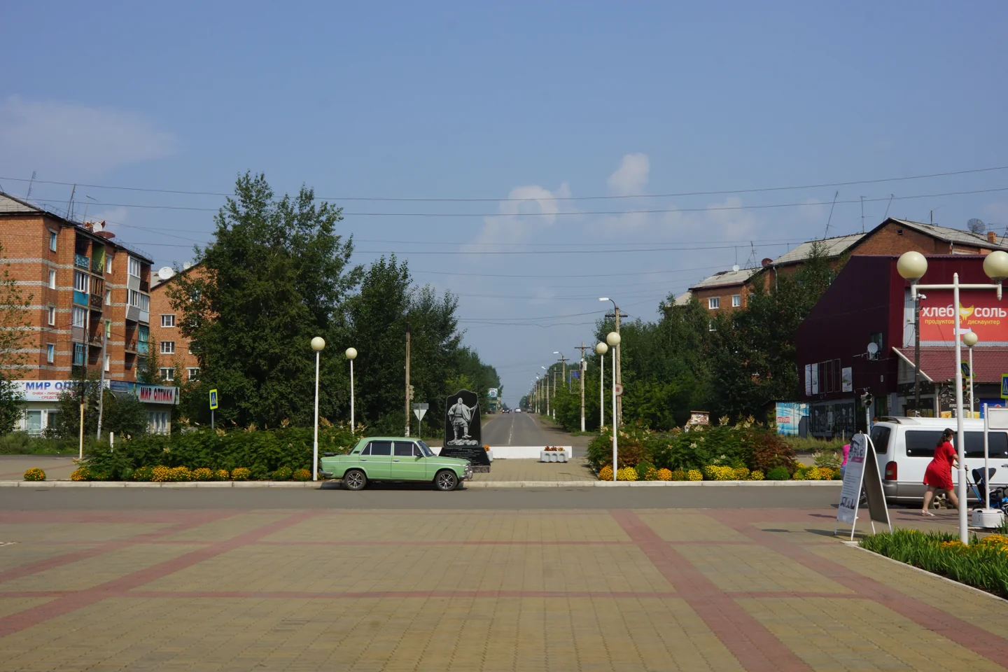
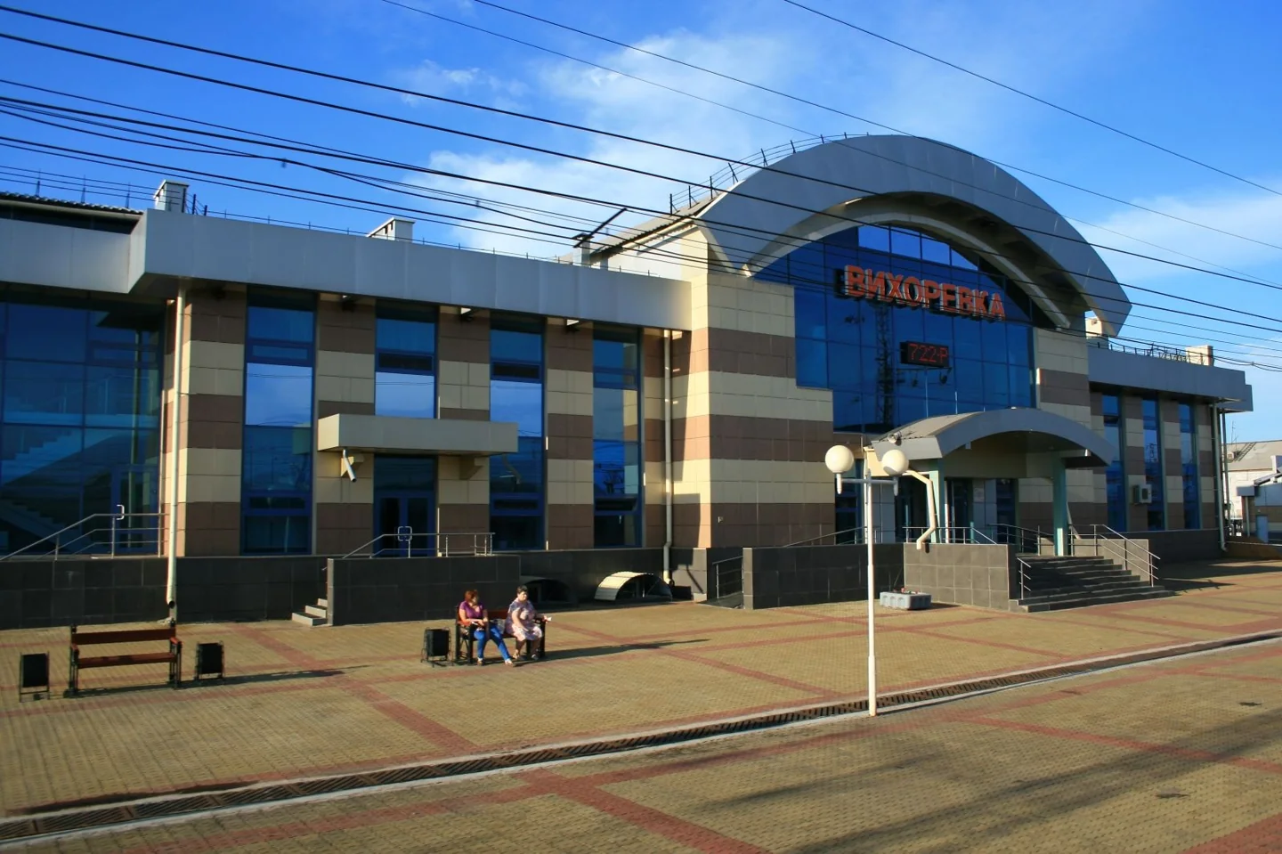
13 August 2020. Looking from the station square towards Lenin Street. Vikhorevka is a town within Bratsk District; the photograph shows its modern urban setting.
2020

Vikhorevka station square

13 August 2020. Looking from the station square towards Lenin Street. Vikhorevka is a town within Bratsk District; the photograph shows its modern urban setting.

Vasily Astanin · Wikimedia Commons · уменьшено, WebP / resized, WebP
CC BY-SA 4.0 · Original ↗
Thirty-two thousand square kilometres of forest, water and roads

The municipal profile gives the district’s area as 3,253,100 hectares, approximately 32,500 square kilometres: far too large to explore in one short outing. Its neighbours are the territories of Ust-Ilimsk, Nizhneilimsk, Ust-Uda, Balagansk, Kuytun, Tulun, Nizhneudinsk and Chuna. Municipal labels can change through reform while those geographical relationships remain.

The Angara Ridge provides a landscape of wooded uplands, valleys and relatively level plateau surfaces. Official figures assign 78 percent of the area to forest-fund land and 11.14 percent to water-fund land. Settlements consequently occupy a much larger environment than their built-up footprints suggest. River valleys, transport corridors and shorelines explain the district’s geography better than any expectation of continuous development.

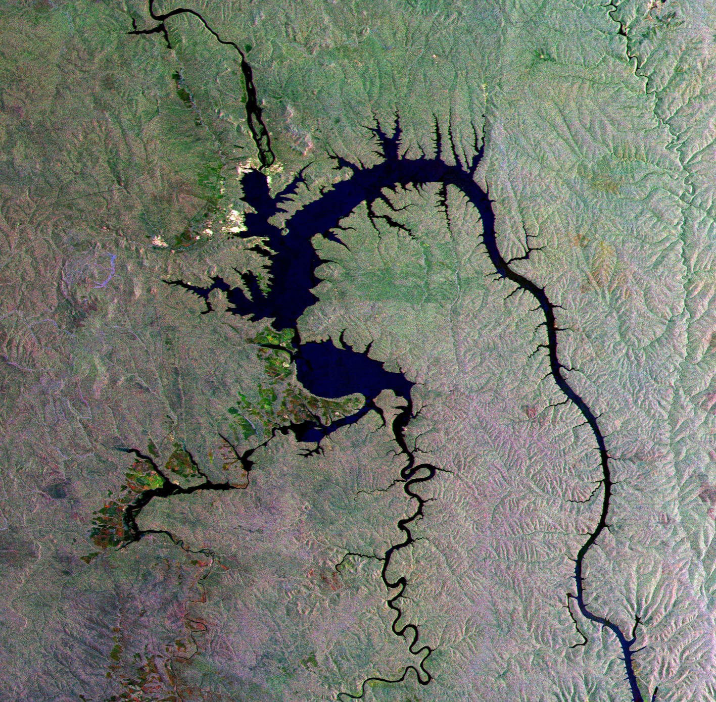
ESA’s radar image “Siberian gecko”, published on 17 December 2010. The branching outline follows inundated valleys. Colours reflect radar imaging and processing, rather than an ordinary natural-colour aerial photograph. Publication is not presented as the exact acquisition date.
≤ 2010

Bratsk Reservoir from Envisat

ESA’s radar image “Siberian gecko”, published on 17 December 2010. The branching outline follows inundated valleys. Colours reflect radar imaging and processing, rather than an ordinary natural-colour aerial photograph. Publication is not presented as the exact acquisition date.

ESA · ESA / Envisat
CC BY-SA 3.0 IGO · Original ↗

Angara, Oka, Iya and Vikhoreva: the district’s water network

The Angara is the principal waterway, but its tributaries are essential to understanding the district. The Oka and Iya form major arms of Bratsk Reservoir, while the Vikhoreva connects Vikhorevka with communities farther north. This Oka belongs to the Angara basin. The Iya, familiar from Tulun’s geography, continues towards district settlements and the reservoir.

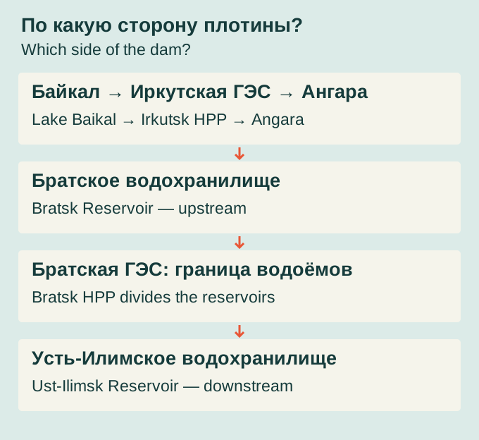
Two artificial reservoirs shape the wider district. Bratsk Reservoir lies upstream of Bratsk HPP and Ust-Ilimsk Reservoir downstream. Their shores formed at different times, producing different relocation histories. Dubynino and old Tangui therefore need separate explanations. The present expanse of water conceals former channels, islands, rapids and roads that once provided the everyday reference points of local life.

Original flow-order diagram showing the two reservoirs relative to Bratsk dam. It represents neither scale nor distances and does not show the entire Angara cascade.
2026 · схема / diagram

Which side of the dam?

Original flow-order diagram showing the two reservoirs relative to Bratsk dam. It represents neither scale nor distances and does not show the entire Angara cascade.

bratsk.com · bratsk.com
CC BY 4.0 · Original ↗

Long winters, short summers and an extensive taiga

The district has a strongly continental climate: a long, cold winter gives way to a relatively short summer. This shapes farming, heating, forestry operations and travel. Seasons even alter how distances are experienced: open-water navigation connects shores, while the transition between seasons can interrupt familiar connections.

The taiga is not uniform. Local geographical descriptions distinguish southern-taiga and subtaiga environments, with woodland adjoining wetlands, fields and large bodies of water. Forest is simultaneously a workplace, a source of wild foods and wildlife habitat. Younger regrowth, older stands and open agricultural land reveal different phases of human activity. Understanding these contrasts makes the landscape more legible than treating the entire district as one undifferentiated stretch of trees.

People lived here long before district boundaries existed

The Angara region’s archaeological history extends back thousands of years. Bratsk’s library account of the Iya describes a 1964 survey in which students led by historian and ethnographer Vladimir Svinin identified nine sites along the river towards Ilir, attributed to the Mesolithic. Finds included worked stone and material used to manufacture tools.

Such evidence changes how a riverbank is understood. Long before agriculture, forestry or leisure, it formed part of ancient patterns of movement and subsistence. The present administrative district should also be distinguished from the scholarly concept of a Bratsk geoarchaeological region: ancient communities did not follow modern municipal boundaries. Dubynino’s local history likewise records archaeological investigations before the transformation of the Angara shores and in later years.

Indigenous communities, the fort and early Russian villages

Russian expansion entered an Angara region already inhabited by Buryat and Evenki communities. Tribute collection, exchange, conflict and river travel shaped these encounters. Bratsk Fort’s foundation in 1631 formed one stage in establishing Russian administration and connected the area with routes extending farther into Siberia.

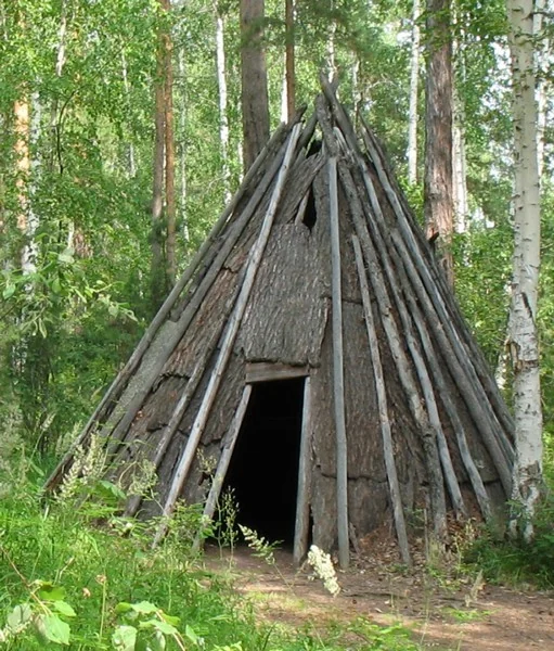
Farming settlements subsequently developed around waterways. Their names preserved Indigenous-language roots, settlers’ names and descriptions of local terrain or livelihoods. Individual etymologies require care: oral traditions and documentary references offer different degrees of certainty. The district’s early history is best understood through the coexistence and interaction of several cultural traditions. The foundation of the fort marks an administrative development within a much older inhabited landscape.

A reconstructed bark-covered dwelling in the Evenki sector.
б/д · undated

A bark-covered chum

A reconstructed bark-covered dwelling in the Evenki sector.

Фотограф не указан / Photographer not named · Братский городской объединённый музей / Bratsk City Museum
© Bratsk City Museum · официальная музейная публикация / official museum publication · Original ↗

Village life before the great construction projects

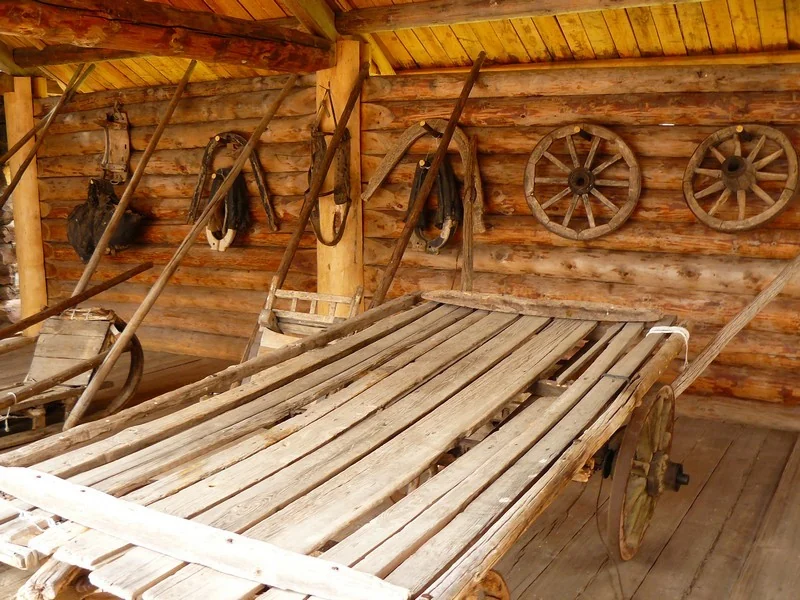
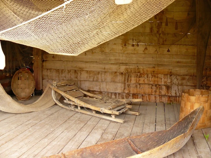
Old Angara livelihoods combined several activities. Fields and livestock sustained households; rivers provided fish and transport; forest supplied building material, fuel and opportunities for hunting and gathering. Houses, granaries, bathhouses, boats and nets belonged to one practical system, with farmyard layouts reflecting work, storage and animal care.

Museum collections and surviving farmsteads help recover that world, provided each object’s origin is respected. Angarskaya Derevnya in Bratsk contains buildings from different parts of Irkutsk Oblast and should not be understood as one relocated Bratsk District village. Particular houses do have direct district connections, notably the Chupin estate from Anchirikovo. A timber facade becomes more informative when connected with identifiable owners, household work and ways of life.

River work in the museum display: a boat, nets and timber storage space.
б/д · undated

Boat and fishing equipment

River work in the museum display: a boat, nets and timber storage space.

Фотограф не указан / Photographer not named · Братский городской объединённый музей / Bratsk City Museum
© Bratsk City Museum · официальная музейная публикация / official museum publication · Original ↗

Domestic weaving equipment in a museum interior, showing the work behind the production of cloth.
б/д · undated

A weaving loom

Domestic weaving equipment in a museum interior, showing the work behind the production of cloth.

Фотограф не указан / Photographer not named · Братский городской объединённый музей / Bratsk City Museum
© Bratsk City Museum · официальная музейная публикация / official museum publication · Original ↗

Nikolaevsky works: metallurgy before the aluminium age

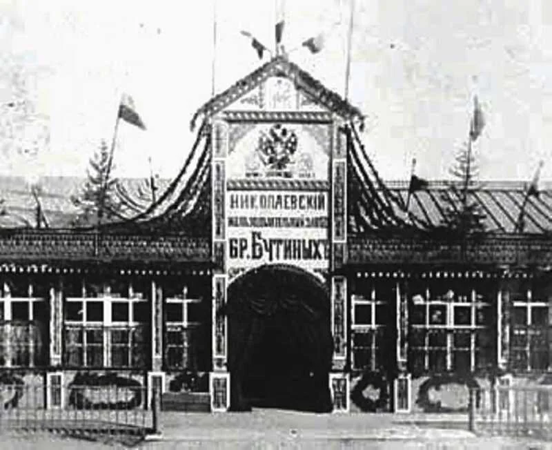
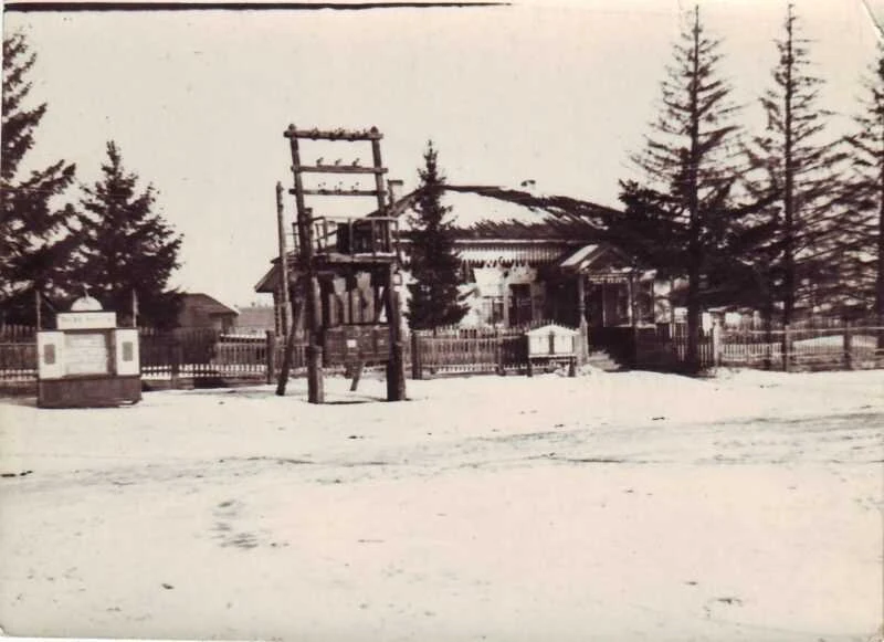
Industry around Bratsk long predates the aluminium smelter. The Nikolaevsky ironworks and foundry operated on the Dolonovka. Liliya Andreyeva’s historical account dates its first metal to 1847 and full operation to 1854. Iron ore, woodland for charcoal and Angara transport connections influenced the choice of location.

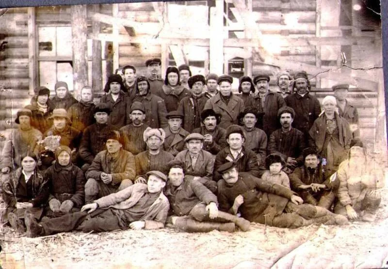
The works served developing Siberian industries, including gold mining. Its history involves entrepreneurs, engineers, workers’ families, periods of growth and commercial crises. Surviving entrance photographs, workers’ portraits and cast-iron objects make this history tangible. Subsequent flooding made documentary and museum evidence especially valuable. This nineteenth-century operation used different raw materials, processes and supply arrangements from the modern aluminium industry with which Bratsk is now associated.

An archival view of the works entrance reproduced in Liliya Andreyeva’s historical account. No exact photograph date is given. The plant belongs to the Angara region’s pre-revolutionary industrial history.
б/д · undated

The Nikolaevsky works entrance

An archival view of the works entrance reproduced in Liliya Andreyeva’s historical account. No exact photograph date is given. The plant belongs to the Angara region’s pre-revolutionary industrial history.

Фотограф не указан / Photographer not identified · Администрация Братского района / Bratsk District administration
© правообладателя / rights reserved · Original ↗

A group photograph captioned “Workers of NZ” in the source. The names and date are unspecified; it accompanies the historical account of the works.
б/д · undated

Workers of the Nikolaevsky works

A group photograph captioned “Workers of NZ” in the source. The names and date are unspecified; it accompanies the historical account of the works.

Фотограф не указан / Photographer not identified · Администрация Братского района / Bratsk District administration
© правообладателя / rights reserved · Original ↗

28 June 1926: the district’s administrative starting point

Bratsk District officially dates its formation to 28 June 1926. It entered Tulun Okrug with Bratskoye village as its administrative centre. This reorganised the administration of existing communities and livelihoods; rural life did not begin when the district acquired its name.

The late-1920s territory combined farming and livestock with hunting and fishing across an extensive taiga landscape. The Tulun road and rivers provided connections. Access to schools, medical care and trade depended heavily on distance. This rural administrative unit supplied the starting point for the centenary celebrated in 2026. Its boundaries changed repeatedly, so historical and present-day statistics do not necessarily describe an identical area or collection of settlements.

Collectivisation and mechanisation transformed village life

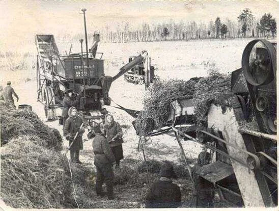
During the 1930s, individual peasant farming gave way to the collective-farm system. The district’s official history records sixty-two collective farms by the 1939 census. Tractors, combines, machine-and-tractor stations and new forms of labour organisation changed agricultural work. These developments also affected ownership, household obligations and rural government.

Aggregate figures conceal different personal experiences. Settlement accounts preserve recollections of repression and forced labour, which need to be read with their provenance identified. Koblyakovo’s later development involved a machine-and-tractor station, workshops and the consolidation of farms. The archival farming photograph reproduced with Kaltuk’s history illustrates machinery becoming part of village work, while also conveying its continuing physical and collective demands.

An archival photograph of farm machinery and workers illustrating the Kaltuk settlement history. The publication does not specify the year or identify the people.
б/д · undated

Harvest work in the Kaltuk historical account

An archival photograph of farm machinery and workers illustrating the Kaltuk settlement history. The publication does not specify the year or identify the people.

Фотограф не указан / Photographer not identified · Администрация Братского района / Bratsk District administration
© правообладателя / rights reserved · Original ↗

The front, evacuation and those who kept working at home

The district’s official history estimates that more than five thousand residents went to the front during the Second World War. Women, adolescents and older people continued work at home: sowing and harvesting, tending livestock, cutting timber and maintaining transport with limited machinery. The district also received evacuees.

Angara river connections remained important for supplies, while farms contributed food and horses. Personal recollections reveal the everyday scale of wartime demands: labour shortages, long working days and household responsibilities after collective work. Village memorials, family documents, school research and archival publications preserve this history. Anyone tracing an individual should compare the name of their pre-war village with relocation records, since the original settlement may no longer appear on a modern map.

Railways, Vikhorevka and prisoner labour

Construction of the Tayshet–Lena railway marked a major turning point. Vikhorevka traces its urban origins to a railway station established in 1947. Tracks required depots, maintenance services, housing and permanent staff; a steam-locomotive depot opened in 1953 and later became a locomotive depot.

Vikhorevka’s official history explicitly records prisoners building the depot. The district chronicle links railway construction and logging with the camp system, including Ozerlag. This belongs within any account of how the infrastructure was created. Forced labour, civilian specialists, organised recruitment and subsequent resettlement existed alongside one another. Some released prisoners remained in the area. The railway town emerged from different personal histories that should retain their distinctions.

Vikhorevka station in an author-contributed Wikimedia Commons photograph. The file page gives 2018; this is a modern view rather than a railway-construction photograph.
2018 · источник / source

Vikhorevka railway station

Vikhorevka station in an author-contributed Wikimedia Commons photograph. The file page gives 2018; this is a modern view rather than a railway-construction photograph.

4ikish · Wikimedia Commons · уменьшено, WebP / resized, WebP
CC BY-SA 4.0 · Original ↗

The dam project transformed the surrounding territory

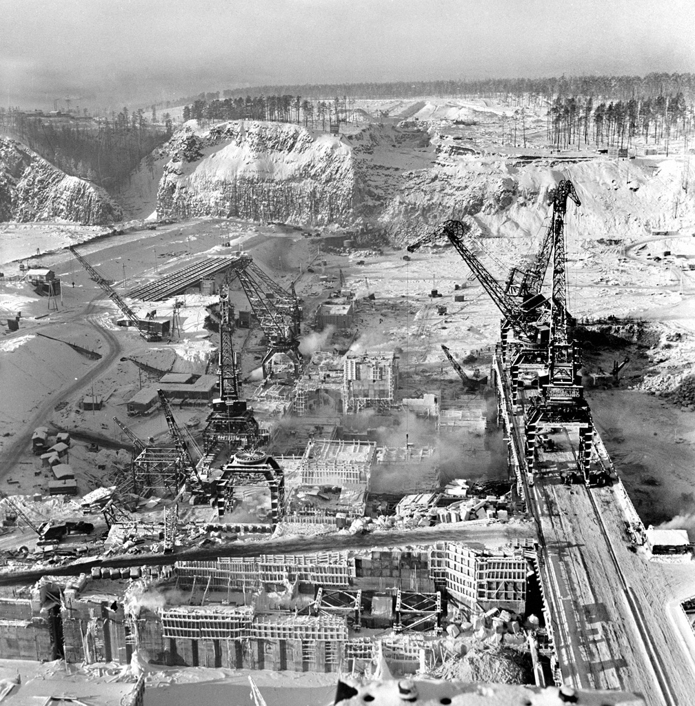
Dam construction beginning in the 1950s changed the scale of economic activity and movement. People and machinery arrived, while demand grew for food, timber, transport and housing. Countless practical connections tied the district to the expanding industrial city.

The effects extended beyond employment. Preparing the reservoir required clearing forests, relocating settlements and creating new roads. A village could lose not only its original site but familiar relationships with neighbouring communities, fields and landing stages. Administrative precision matters here: the HPP and major city factories belong to Bratsk’s history, while the district supplied them, received relocated communities and experienced the transformation of a much wider landscape. Their interconnected histories involve different territories and economic statistics.

1 February 1960. The Bratsk dam construction site.
1960

Building the Bratsk hydroelectric station

1 February 1960. The Bratsk dam construction site.

Макс Альперт / Max Alpert · РИА Новости / RIA Novosti, № 791507
CC BY-SA 3.0 · Original ↗

Relocation: moving a house was easier than moving a whole way of life

Filling Bratsk Reservoir in 1961–1967 divided the histories of many villages. Some residents moved to new settlements bearing familiar names; others went to service centres, logging settlements or the city. Houses were dismantled and reassembled, schools built and households reorganised. Later, Ust-Ilimsk Reservoir brought further changes downstream.

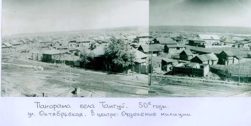
The phrase “the village was moved” conceals many different decisions. Families relocated, with varying timetables, housing conditions and feelings about departure. Old Tangui is particularly well documented through photographs and museum records. Dubynino retains houses brought from other places. These examples help distinguish the two reservoir projects and clarify that old and new settlements often occupy different sites.

Archival panorama identified as Tangui in the 1950s in the municipal publication. Timber buildings and a village street are visible. Old and new Tangui occupy different sites.
1950-е · 1950s

Panorama of old Tangui

Archival panorama identified as Tangui in the 1950s in the municipal publication. Timber buildings and a village street are visible. Old and new Tangui occupy different sites.

Автор не указан / photographer not identified · Музей с. Тангуй / администрация Братского района
© правообладателя / rights reserved · Original ↗

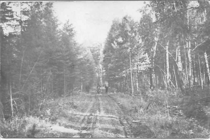
Archival photograph captioned “The road to new Tangui”. The forest track evokes the early development of the new site; the source does not identify the exact year or people pictured.
б/д · undated

The road to new Tangui

Archival photograph captioned “The road to new Tangui”. The forest track evokes the early development of the new site; the source does not identify the exact year or people pictured.

Автор не указан / photographer not identified · Музей с. Тангуй / администрация Братского района
© правообладателя / rights reserved · Original ↗

Why historical district maps differ from today’s

Bratsk District’s boundaries changed repeatedly. Part of its territory entered Tangui District in 1935, and Zayarsk District existed during the post-war period. Industrial growth and Bratsk’s acquisition of city status brought further administrative reorganisation. The district executive committee was abolished in 1958 and re-established in January 1963 following the separation of the rural district.

Ust-Ilimsk District was created from Bratsk territory in 1968. A historical document labelled “Bratsk District” can therefore concern a place now administered elsewhere. This matters for family research, local history and population comparisons. Establishing the date and territorial coverage of a source should precede comparison with a present-day map: settlement names can outlast several changes of administrative affiliation.

One town, rural municipalities and fifty-nine settlements

The official profile, updated in February 2026, lists fifty-nine inhabited places. Its municipal structure comprises Vikhorevka’s urban settlement and twenty-three rural settlements, plus inter-settlement territory following the abolition of Tynkob’s municipality in 2018. In this context, a “settlement” is an administrative grouping that can include several villages or communities.

For 1 January 2025, the administration records 46,584 residents: 21,092 urban and 25,492 rural. These are dated figures from the district profile, rather than a live population count. Almost half the population lives in Vikhorevka, with the remainder spread across numerous rural communities. That distribution helps explain the importance of transport, medical access, schools and communications to district life.

Complete index: all fifty-nine inhabited places

The names below follow Annex 5 to regional Law No. 119-OZ of 26 December 2025, which describes the future municipal okrug. Its total matches the fifty-nine inhabited places in the district’s 2026 profile. Bratsk city is absent from this list.

Town: Vikhorevka.

Villages classified as derevnya in the annex: Anchirikova, Bada, Barchim, Bulak, Vorobyovo, Karay, Kardoy, Kuvatka, Kumeyka, Leonova, Novoye Prirechye, Khakharey and Khudobok.

Settlements classified as posyolok: Bambuy, Borovskoy, Burninskaya Vikhorya, Dobchur, Zyaba, Karakhun, Kezhemsky, Lugovoy, Mamyr, Naratai, Novodolonovo, Ozerny, Oktyabrsk, Pashenny, Pervomaysky, Podvyezdny, Priboyny, Pribrezhny, Pridorozhny, Sakhorovo, Sosnovy, Tarma, Tukovsky, Turma, Tynkob, Kharanzhino, Khvoyny, Cheremshanka, Chisty, Chistyakovo, Shumilovo and Yuzhny.

Villages classified as selo: Alexandrovka, Bolsheokinskoye, Dubynino, Zarb, Ilir, Kaltuk, Klyuchi-Bulak, Koblyakovo, Kob, Kuznetsovka, Pokosnoye, Tangui and Tem.

This index helps identify an exact place name. Inhabited places and municipal settlement groupings are different counts, because a single administrative unit can contain several communities.

Vikhorevka: a town that grew from a railway station

Vikhorevka is the district’s only town and a major transport and community centre. Its railway history begins in 1947; it became a workers’ settlement in 1957 and acquired town status in 1966. Depots, maintenance and operating divisions, railway housing and public institutions developed together.

Rail explains much of its biography, while contemporary Vikhorevka also serves surrounding communities through commerce, education and culture. Its history records important logging and timber-processing activity. Residents arrived through professional assignments, labour recruitment and reservoir resettlement; others stayed after release from the camps. The station square and residential streets reveal the district’s urban dimension. Vikhorevka deserves time as a place in its own right, beyond the name printed on a railway ticket.

13 August 2020. Looking from the station square towards Lenin Street. Vikhorevka is a town within Bratsk District; the photograph shows its modern urban setting.
2020

Vikhorevka station square

13 August 2020. Looking from the station square towards Lenin Street. Vikhorevka is a town within Bratsk District; the photograph shows its modern urban setting.

Vasily Astanin · Wikimedia Commons · уменьшено, WebP / resized, WebP
CC BY-SA 4.0 · Original ↗
Vikhorevka station in an author-contributed Wikimedia Commons photograph. The file page gives 2018; this is a modern view rather than a railway-construction photograph.
2018 · источник / source

Vikhorevka railway station

Vikhorevka station in an author-contributed Wikimedia Commons photograph. The file page gives 2018; this is a modern view rather than a railway-construction photograph.

4ikish · Wikimedia Commons · уменьшено, WebP / resized, WebP
CC BY-SA 4.0 · Original ↗
Tangui: a former district centre on a new shore

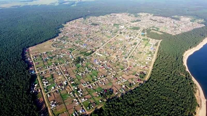
Tangui has a long history of its own and served as the centre of a separate district in 1935–1959. The old village developed beside the Iya; reservoir creation required residents to establish a new site. Archival panoramas and modern aerial photographs show different places connected by a shared name and family memory.

The museum’s relocation account records a new school being built in 1960 and opening on 1 September 1961. Such dates make resettlement tangible through everyday institutions. The administration’s directory includes Alexandrovka, Zarb, Khudobok, Bada and Vorobyovo within Tangui’s municipal grouping. Local cultural life preserves historical research, museum evidence and village performance. Exploring Tangui means considering both the lost settlement and the practical creation of a new community after its whole shoreline geography changed.

Public building in the old village centre. The publication associates it with the district party committee; its caption and account trace institutions affected by relocation. The exact photograph date is not supplied.
б/д · undated

The public centre of old Tangui

Public building in the old village centre. The publication associates it with the district party committee; its caption and account trace institutions affected by relocation. The exact photograph date is not supplied.

Автор не указан / photographer not identified · Музей с. Тангуй / администрация Братского района
© правообладателя / rights reserved · Original ↗

2022, according to the source caption. The relocated village has streets, homesteads, forest and a reservoir shore. It is not a repeat view from the same position as the old Tangui panorama.
2022

New Tangui from above

2022, according to the source caption. The relocated village has streets, homesteads, forest and a reservoir shore. It is not a repeat view from the same position as the old Tangui panorama.

Автор не указан / photographer not identified · Музей с. Тангуй / администрация Братского района
© правообладателя / rights reserved · Original ↗

Bolsheokinskoye and Novodolonovo: river names and relocated communities

Bolsheokinskoye is a rural centre whose history connects the Oka, farming and resettlement. The current district directory groups it with Novodolonovo. Both names preserve a historical geography substantially altered by the reservoir, with older communities and economic relationships continuing on new sites.

The 2023 Faces of Flooded Villages project recorded recollections in Bolsheokinskoye and other district settlements. Its participants described places including old Bolsheokinsk and Dolonovo. These accounts measure relocation through particular homes, jobs and families rather than abstract numbers. Visiting the area offers a way to connect agriculture with the history of industrial development. Novodolonovo also appears in Tarma’s timber-enterprise history, linking several strands of the district’s past.

Kaltuk: from farming village to sailing regattas

The local-history gazetteer places Kaltuk’s first recorded mention in 1723. Its later history combines agriculture, collective-farm consolidation and residents relocated from Malaya and Bolshaya Kada. Several earlier communities therefore contributed to the village’s development. Elders’ recollections describe farmyards, a mill, household work and difficult wartime years.

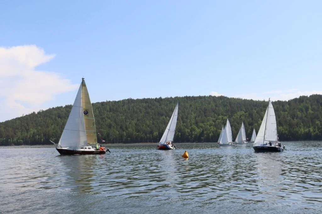
The local account identifies 19 June 1961 as the date Kaltuk’s hospital received its first patients. It served neighbouring settlements as well as the village itself. Contemporary Kaltuk also has a conspicuous leisure connection: reservoir sailing. In June 2026, eleven crews entered the third regatta, dedicated to the district’s centenary. Agriculture, medical services for the surrounding area and yachts on the bay belong to the biography of the same place.

Yachts on the reservoir in the June 2026 report on Kaltuk’s third regatta, dedicated to Bratsk District’s centenary.
2026

A sailing regatta near Kaltuk

Yachts on the reservoir in the June 2026 report on Kaltuk’s third regatta, dedicated to Bratsk District’s centenary.

Фотограф не указан / Photographer not identified · Администрация Братского района / Bratsk District administration
© правообладателя / rights reserved · Original ↗

Klyuchi-Bulak, Leonova and Kumeyka: village life and Vertikal

Klyuchi-Bulak’s municipal grouping includes Klyuchi-Bulak village together with Leonova and Kumeyka. Shared administration helps organise services, while each community retains its own families and memory. District history connects these places with agricultural change and the transformation of the Angara shores.

Klyuchi-Bulak is also known for the Vertikal singer-songwriter festival. Its fourth edition took place in July 2026, bringing together performers and listeners from communities including Kaltuk and Pribrezhny. The event reveals the district as a place of living culture, where guitars, original songs and outdoor gatherings build connections across considerable distances. Future festival dates should be checked in new organisers’ announcements; historical coverage documents an event that has already taken place.

Ilir and neighbouring communities: the district’s southern rural history

Ilir’s municipal grouping comprises Ilir, Kardoy, Karay and Lugovoy. This is a distinct rural part of the district, with institutions and a history connected to river valleys and farming. Kardoy and Karay both occur in historical material, and their similar names should be carefully distinguished.

Ilir also appears in the archaeological account of surveys along the Iya valley. Its cultural and leisure centre remains an important institution: for the district centenary, it prepared a photographic history exhibition, while the village hosted anniversary activities and children’s rural games in 2026. Such local institutions keep history accessible within the community. School research, village photograph collections and family accounts can provide detail that broad district histories necessarily leave out.

Pokosnoye: a rural centre with its own cultural history

Pokosnoye’s municipal grouping includes Pokosnoye village and Sosnovy settlement. It functions as one of the district’s rural centres, combining everyday services with cultural institutions. Schools, agriculture, the library, music education and the cultural centre all provide ways into its history.

The cultural centre’s description on Kultura.RF preserves an episode involving singer Iosif Kobzon’s visit during a creative trip to the dam and power-line builders. The district chronicle also records the development of arts education from the local music school. These details show a village with a stage, an audience and an established cultural environment alongside its productive role. Exploring Pokosnoye means considering institutions used by several generations as well as the surrounding agricultural landscape.

Tem and Barchim: an old name carried through relocation

Tem’s municipal grouping includes Tem village and Barchim. Its history combines old Angara life with relocation from the Bratsk Reservoir zone. The documentary project about flooded villages explicitly includes old Tem among the places remembered by participants. Individual accounts reveal departure, work in a new setting and the preservation of family connections.

The village has its own published historical record: the regional bibliography lists Tem: From the Past into the Future, associated with the settlement’s three-hundredth anniversary. It offers a route towards names, documents and local detail. Cultural institutions also sustain present-day community life. In December 2025, the district newspaper reported a library renovation through a community initiative project, connecting the larger history of relocation with practical collective work in a living village.

Kuznetsovka and Bambuy: from a smallholding to farming communities

Vladimir Gerasimov’s local-history gazetteer traces Kuznetsovka to a recorded Kuznetsov smallholding in 1863. The settlement remained small into the mid-twentieth century; later growth involved an agricultural enterprise and community institutions. The present district directory groups it with Bambuy.

Older reference accounts describe milk, grain and vegetable production alongside a school, library and cultural centre. Their numerical figures belong to the dates of compilation and should not be treated as a current village profile. They do explain its character: agricultural work supported permanent households, which required education and cultural facilities. Enterprise history becomes more informative when connected with family photographs and residents’ recollections, revealing the people behind the production and construction of a rural centre.

Koblyakovo: old houses, a machinery station and the Kolos club

Koblyakovo’s history can be read through successive layers of rural development. The local account describes an early-twentieth-century credit association, collective farming, a machine-and-tractor station and a later state farm. Industrial Bratsk needed agricultural supplies, while the neighbouring community expanded production and public institutions.

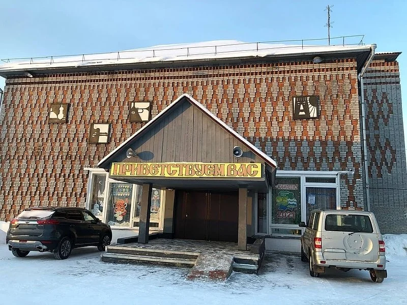
Local memory also recalls Ivan Naymushin’s assistance after a fire, followed by new houses and a street bearing his name. Later development stands alongside older timber homes. The published photograph dates the cultural-centre building to 1985. Koblyakovo’s municipal grouping also includes Anchirikovo, Dubynino, Sakhorovo and Burninskaya Vikhorya: separate community histories within one administrative unit. Dubynino and the house from Anchirikovo therefore receive their own sections below.

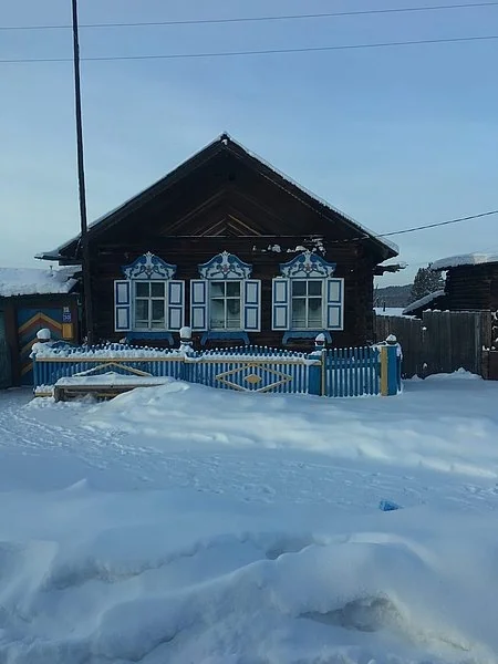
A wooden house identified in the local-history publication as standing in the old part of Koblyakovo. The owner and photograph date are not supplied.
б/д · undated

A house in old Koblyakovo

A wooden house identified in the local-history publication as standing in the old part of Koblyakovo. The owner and photograph date are not supplied.

Фотограф не указан / Photographer not identified · Журнал «Прибайкалье» / Pribaikalye magazine
© правообладателя / rights reserved · Original ↗

The source identifies this as the Koblyakovo club built in 1985. The photograph is undated; 1985 refers to the building.
б/д · undated

Kolos cultural centre in Koblyakovo

The source identifies this as the Koblyakovo club built in 1985. The photograph is undated; 1985 refers to the building.

Фотограф не указан / Photographer not identified · Журнал «Прибайкалье» / Pribaikalye magazine
© правообладателя / rights reserved · Original ↗

Dubynino: rapids, timber houses and a transformed Angara

Dubynino combines an old river-settlement history with changes brought by Ust-Ilimsk Reservoir. Its local account records earlier village names and the difficult Dolgy, or Dubynino, rapid. Unlike communities above Bratsk HPP, this story concerns another dam and another phase of shoreline transformation.

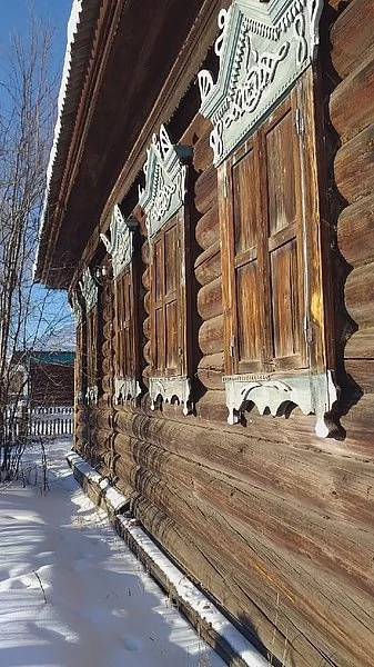
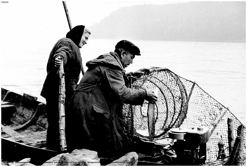
Timber houses survive in the village, including buildings moved from nearby places. One published photograph identifies a carved house brought from Moskovskoye. Edgar Bryukhanenko’s archival picture of local fishers recalls the importance of river livelihoods. Traditions explaining the village name should be understood as traditions, with documentary confirmation considered separately. Buildings, photographs, archaeological evidence and the present shoreline provide tangible ways into a geography now partly concealed beneath water.

An old house in Dubynino, identified by the source as relocated from Moskovskoye. The photograph reveals its carved details and timber facade.
б/д · undated

A house relocated from Moskovskoye

An old house in Dubynino, identified by the source as relocated from Moskovskoye. The photograph reveals its carved details and timber facade.

Фотограф не указан / Photographer not identified · Журнал «Прибайкалье» / Pribaikalye magazine
© правообладателя / rights reserved · Original ↗

An archival photograph of fishers from Dubynino. The publication credits Edgar Bryukhanenko; it does not give a precise year.
б/д · undated

Fishers from Dubynino

An archival photograph of fishers from Dubynino. The publication credits Edgar Bryukhanenko; it does not give a precise year.

Эдгар Брюханенко / Edgar Bryukhanenko · Журнал «Прибайкалье» / Pribaikalye magazine
© правообладателя / rights reserved · Original ↗

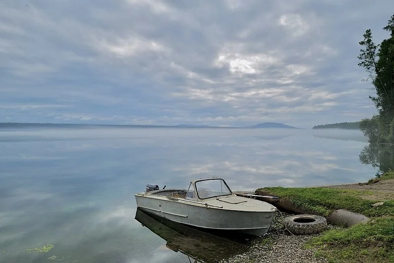
A boat and shore in the local-history account, captioned as the waters covering Dubynino’s historical site. This is a modern landscape, not a pre-relocation view of the village.
б/д · undated

Water beside Dubynino’s former site

A boat and shore in the local-history account, captioned as the waters covering Dubynino’s historical site. This is a modern landscape, not a pre-relocation view of the village.

Фотограф не указан / Photographer not identified · Журнал «Прибайкалье» / Pribaikalye magazine
© правообладателя / rights reserved · Original ↗

Anchirikovo: the journey of the Chupin family house

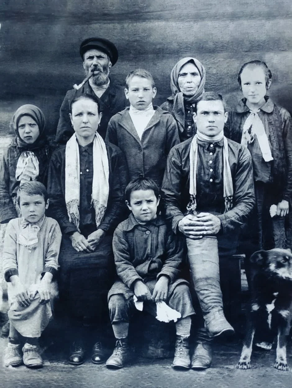
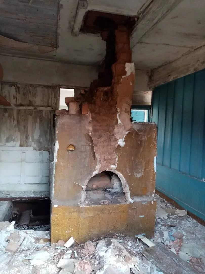
Anchirikovo is associated with the Chupin estate transferred to Angarskaya Derevnya museum. Its history follows a family household into museum preservation. An inscription on the clay stove helped establish 1925 as the house’s construction year. Family photographs, descendants’ recollections and restoration records survive.

Preserving the house required work on its timber structure, interior and details that could not be reconstructed from the facade alone. It opened as the museum’s fifth Russian farmstead in 2022. Visitors see the outcome of extensive preservation work, while archival photographs record earlier stages of the house and stove. The museum stands in Bratsk, but this building’s biography began in a district village, allowing a twentieth-century rural history to be explored through one family and its everyday surroundings.

A family photograph from the account of the Chupin estate. The source identifies Pyotr Andreyevich Chupin and his wife Ustinya Feoktistovna; no precise year is supplied.
б/д · undated

The Chupin family of Anchirikovo

A family photograph from the account of the Chupin estate. The source identifies Pyotr Andreyevich Chupin and his wife Ustinya Feoktistovna; no precise year is supplied.

Фотограф не указан / Photographer not identified · Администрация Братского района / Bratsk District administration
© правообладателя / rights reserved · Original ↗

The stove in a photograph accompanying the house’s history. It records a stage in the restoration archive rather than the present appearance of the museum interior.
б/д · undated

The Chupin house’s clay stove

The stove in a photograph accompanying the house’s history. It records a stage in the restoration archive rather than the present appearance of the museum interior.

Фотограф не указан / Photographer not identified · Администрация Братского района / Bratsk District administration
© правообладателя / rights reserved · Original ↗

Tarma: a temporary logging settlement that endured

Tarma’s official settlement history connects its origins with forest clearance for the future reservoir in 1956–1960. Initially conceived as temporary accommodation for about five years, it acquired a permanent life through timber production and resettlement. Summer 1961, when the first houses appeared, is treated as the settlement’s starting point.

Residents arrived from Yelanka, Dolonovo, Dunayka and the Nikolaevsky works community, alongside recruited workers. Establishing the Bratsk timber enterprise in Tarma in July 1961 strengthened its economic base. The account identifies Druzhby Street, Oktyabrsky Lane, a hostel and early managers. Such details show a technical forest-clearance assignment developing into an enduring inhabited place. The label “temporary” proved much shorter-lived than the community itself.

Zyaba: a settlement and station distinct from the city beach

Zyaba’s municipal grouping includes Zyaba, Borovskoy, Pashenny and Podvyezdny. The settlement is associated with rail transport and forestry. A small autumn street photograph in the local gazetteer provides an identifiable view of the inhabited place.

Visitors need to distinguish it from another everyday use of the name. Bratsk residents also call the reservoir bay, beach and dacha area near Bratskoye Vzmorye “Zyaba”. The shared name can confuse route searches and photograph identification. The district settlement and leisure area require different location descriptions. River names have often passed to stations, villages and recreational sites across the Angara region, making the date and geographical context of any reference particularly useful.

Small source image captioned “View of Zyaba settlement. Autumn” in the local-history entry. It shows the separate Bratsk District settlement, not the beach near Bratskoye Vzmorye. No exact date or photographer is supplied.
б/д · undated

Zyaba settlement in autumn

Small source image captioned “View of Zyaba settlement. Autumn” in the local-history entry. It shows the separate Bratsk District settlement, not the beach near Bratskoye Vzmorye. No exact date or photographer is supplied.

Автор снимка не указан / photographer not identified · Имена Братска / справка о посёлке Зяба
© правообладателя / rights reserved · Original ↗

Pribrezhny, Novoye Prirechye and Chistyakovo

Pribrezhny’s municipal grouping includes Pribrezhny, Novoye Prirechye and Chistyakovo. Their names suggest a river setting, while historical records reveal changing economic and social connections. The district chronicle includes Pribrezhny among communities receiving television-relay facilities during the 1980s, a significant expansion of information access for an outlying settlement.

The Pribrezhny cultural centre also participates in the wider cultural network; district reporting records its puppet theatre attending festivals. A shared administration does not make all three communities one continuous built-up place. Keeping their names distinct remains useful for addresses, family research and travel. Small settlements can be connected through services and creative activity while retaining their own physical settings and local identities.

Naratai, Ozerny, Priboyny and Shumilovo

Naratai, Ozerny, Priboyny and Shumilovo are separate rural centres on the district map; Ozerny’s grouping also includes Pervomaysky. Their water-related names do not make them one continuous resort shoreline. They have different histories, access routes and community settings.

Forestry and the transformation of the Angara landscape shaped this part of the district. Shumilovo’s shipyard appears in the pre-war economic account, while historical records of Naratai occur in material concerning preparations for resettlement. Naratai also participated in the Faces of Flooded Villages documentary project. These remain inhabited communities connecting woodland, water and settlement history. Planning a particular visit requires an operating road or water connection; two nearby points on a map can be separated by a much longer practical journey.

Dobchur, Kob and Kuvatka: different strands of rural Angara life

Dobchur’s municipal grouping comprises Dobchur and Khakharey; Kob and Kuvatka form separate rural units. The list illustrates how local administration varies in scale, covering several places in some cases and a single community in others. Aggregate population figures cannot convey each settlement’s daily circumstances.

Kob and Kuvatka took part in the project recording memories of flooded villages, which includes old Kob and old Kuvatka among historical names. Dobchur also appears in the district’s transport history: the administration’s 2022 report names the Dobchur ferry crossing. These references connect the preservation of rural memory with the continuing need for reliable access. Family history and the practical question of reaching neighbours, medical services or home belong to the same lived geography.

Karakhun, Kezhemsky, Turma and Kharanzhino: a network of taiga settlements

Karakhun’s grouping includes Yuzhny; Kezhemsky’s includes Mamyr; Kharanzhino’s includes Oktyabrsk. Turma forms a separate municipal grouping. These names recur in district records concerning schools, culture, roads and utilities. They identify distinct settlements rather than neighbourhoods of Bratsk.

Developing taiga production communities required more than workplaces. A clearly dated example is the secondary school opened in Karakhun in 1970, recorded in the district chronicle. Families, education, a club and library accompanied industrial activity. Older sources provide population and institutional-capacity figures useful for historical study but requiring verification before present-day use. This network reveals how forestry helped create an extensive settlement geography beyond the major industrial city.

Forest: a resource, workplace and interconnected economy

Forestry is listed among the district’s principal economic sectors. Logging connects forest roads, machinery, maintenance, sorting, transport, processing and several specialised occupations. Settlements developed dependencies on this system over decades. Tarma offers a clear example of forest clearance for the reservoir evolving into a permanent timber enterprise.

The district connects with Bratsk’s larger forest-products cluster, while BLPK itself stands within the city. A city plant’s output should therefore be distinguished from district industrial statistics. Following the supply chain is more informative: where timber is harvested, how it moves, where it is processed and which communities house workers. Regeneration, road maintenance and fire protection have both environmental and economic consequences. Forest management influences the future of many local communities.

Agriculture beside a major industrial city

Farming and livestock form enduring strands of district history. They predate the dam and continued through collectivisation, state farms, relocation and the economic changes of the 1990s. The administration lists twenty-five agricultural enterprises in its register for 1 January 2026. That figure describes registered producers rather than every household keeping animals or growing vegetables.

Food has long connected town and countryside. Koblyakovo, Kaltuk, Kuznetsovka and other rural areas contributed different forms of production. Farming and smaller family enterprises now participate alongside larger businesses, with fairs linking producers and customers. Seasonality, storage, transport costs and labour availability all matter. The agricultural calendar includes winter animal care, machinery preparation and deliveries as well as the more immediately visible summer fields.

Roads, railways, ferries and seasonal distances

Several transport systems overlap across the district. Rail is especially important in Vikhorevka and station settlements. Roads connect rural centres with Bratsk and neighbouring territories. Water, once the principal route, became both a connection and a barrier after reservoir creation: nearby shores may require a long road detour or a crossing.

The administration’s 2022 report specifically names the Dobchur and Kantin ferry crossings. It documents transport work in that year rather than providing a current timetable. Practical journeys require recent carrier and administration information because navigation, weather and access conditions vary. Seasonal transitions make the district’s geography particularly clear. A straight line on a screen does not represent actual accessibility, and a summer route may not remain available throughout the year.

Vikhorevka station in an author-contributed Wikimedia Commons photograph. The file page gives 2018; this is a modern view rather than a railway-construction photograph.
2018 · источник / source

Vikhorevka railway station

Vikhorevka station in an author-contributed Wikimedia Commons photograph. The file page gives 2018; this is a modern view rather than a railway-construction photograph.

4ikish · Wikimedia Commons · уменьшено, WebP / resized, WebP
CC BY-SA 4.0 · Original ↗
Schools and medical services sustain settlement life

A school or hospital opening represents a major event in district history. Such institutions support families, help maintain permanent communities and connect smaller villages with rural service centres. The early-2026 profile lists schools, preschool organisations, Vikhorevka’s children’s creativity centre, the district hospital and its network of medical units.

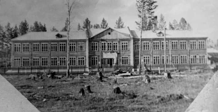
Distance is a continuing operational challenge. Teachers, doctors, drivers, preschool staff and utility workers participate in the same system of everyday rural life. The archival photograph of the new Tangui school demonstrates how education accompanied resettlement. Kaltuk’s hospital historically served neighbouring communities from 1961. Reporting on the administration’s 2025 work continues these themes through medical facilities, repairs and staff recruitment. Reliable public services matter alongside production in determining how communities endure.

1960: the two-storey school under construction. The local chronicle dates its opening, with 240 places, to 1 September 1961. This is the new village, not a building at the site destined for flooding.
1960

Building the school in new Tangui

1960: the two-storey school under construction. The local chronicle dates its opening, with 240 places, to 1 September 1961. This is the new village, not a building at the site destined for flooding.

Автор не указан / photographer not identified · Музей с. Тангуй / администрация Братского района
© правообладателя / rights reserved · Original ↗
Libraries, village stages and a shared cultural network

The district profile lists cultural centres, arts and music schools and an inter-settlement library with rural branches. Together they form a distributed network: a concert or exhibition can begin in one village and continue elsewhere. A local club or library may combine meeting place, classroom, performance venue and repository of photographs.

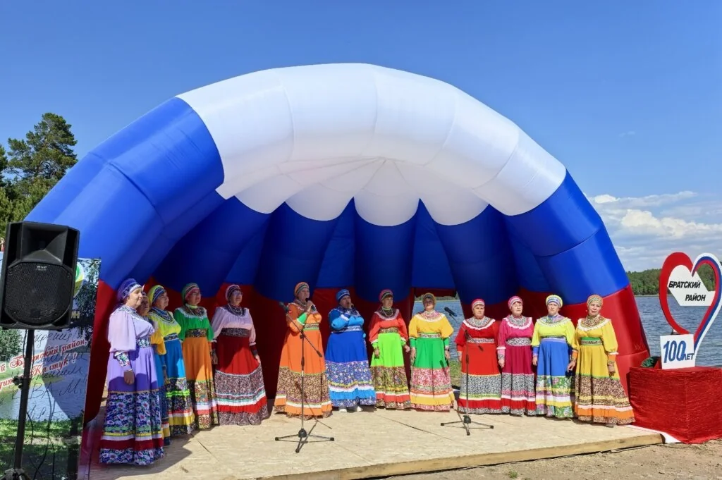
The 2026 centenary made these connections particularly visible. Performers travelled to Kaltuk from Karakhun, Kuvatka, Kezhemsky, Leonova, Ilir, Kumeyka, Kob, Pokosnoye, Vikhorevka and other communities. Each name represented a local creative environment. Songwriting, theatre, singing, dance, historical exhibitions and children’s activities continue between major anniversaries. Village libraries also remain valuable starting points for anyone researching the history of a particular settlement.

A performance at Kaltuk’s “District celebrated in the heart” event. The district administration published its report in June 2026.
2026

The centenary stage at Kaltuk

A performance at Kaltuk’s “District celebrated in the heart” event. The district administration published its report in June 2026.

Фотограф не указан / Photographer not identified · Администрация Братского района / Bratsk District administration
© правообладателя / rights reserved · Original ↗

Small objects reveal a larger industrial history

A disappeared or flooded place may survive through a portable object: a factory product, family photograph or household fitting. The Nikolaevsky works account reproduces museum cast-iron objects, including a waffle maker bearing a double-headed eagle. They connect industrial production with the everyday lives of makers and customers.

A preserved timber house works similarly. Its stove, layout, alterations and family documents matter alongside its size and carving. Memorials keep places within public memory even where the original buildings have disappeared. Museum visitors benefit from checking each object’s provenance: its present home may be far from the settlement where it was used. Across Bratsk District, material memory has travelled with people and acquired new lives in museums and family collections.

A museum object illustrating the Nikolaevsky works history: a cast-iron waffle maker bearing a raised double-headed eagle. The photograph shows an artefact rather than an operating factory.
б/д · undated

A cast-iron waffle maker in a museum collection

A museum object illustrating the Nikolaevsky works history: a cast-iron waffle maker bearing a raised double-headed eagle. The photograph shows an artefact rather than an operating factory.

Фотограф не указан / Photographer not identified · Администрация Братского района / Bratsk District administration
© правообладателя / rights reserved · Original ↗

Muzhichok, the Dubynino rock pillars and reservoir shores

The district’s nature coverage highlights Muzhichok, between the Oka and Anginsky Bay of Bratsk Reservoir. A report citing Rosreestr gives its elevation as 478 metres and explains the name through a summit profile resembling a man wearing a cap. This is elevation above sea level, rather than a measure of the climb’s length or difficulty.

The local-history route around Koblyakovo and Dubynino also includes the Dubynino rock pillars and Angara shoreline sites. These landscapes connect scenery with settlement, fishing and archaeology. A landmark name alone does not establish access: one place may have a road, another require water transport or local guidance. Choosing a specific site according to season and current conditions leaves enough time for the journey as well as the destination.

A boat and shore in the local-history account, captioned as the waters covering Dubynino’s historical site. This is a modern landscape, not a pre-relocation view of the village.
б/д · undated

Water beside Dubynino’s former site

A boat and shore in the local-history account, captioned as the waters covering Dubynino’s historical site. This is a modern landscape, not a pre-relocation view of the village.

Фотограф не указан / Photographer not identified · Журнал «Прибайкалье» / Pribaikalye magazine
© правообладателя / rights reserved · Original ↗

Sailing, fishing and shoreline leisure are part of contemporary life

The reservoirs disrupted older livelihoods but also became settings for new activities. Kaltuk’s sailing regatta offers a well-documented example. Festivals and shoreline gatherings reveal another dimension of a territory often associated with forestry and agriculture. Some residents make short leisure visits; others maintain long-standing working or recreational relationships with the water.

The archival photograph of Dubynino fishers suggests both continuity and change. Reservoir depths, shorelines and travel conditions differ from those of the former Angara. Historical fishing descriptions do not predict present catches, and a photograph of calm water does not establish conditions for a whole day. Current local organisers and recent information are more useful for practical arrangements. History explains how the water landscape emerged and became part of district life.

Three ways to begin exploring the district

A visit to Vikhorevka can focus on railway history, using the station, station square and story of the town’s growth as a starting point. A different approach follows rural Angara heritage through Koblyakovo and Dubynino: timber houses, a cultural centre, the shoreline and relocation histories. These are separate themes and routes, rather than stops on one compulsory day-long circuit.

A third approach centres on the Oka, rural communities and reservoir history, selecting Kaltuk, Bolsheokinskoye, Klyuchi-Bulak or Tangui according to personal interests. Sailing, festivals, family addresses or village libraries may supply the focus. These are editorial trip ideas rather than a published excursion timetable. Identifying the exact destination and available transport before departure allows time for conversations and careful observation instead of simply accumulating stops.

Tracing a family village that disappeared beneath the water

Family research benefits from a few precise starting points: a surname, the old village name, an approximate year and its administrative affiliation at that time. District chronicles, archival inventories, resettlement lists, photographs and recollections can then be compared. A modern place with the same name may occupy a different site, while a new community may have received residents from several villages.

Village libraries, school research, museum staff and descendants provide useful connections. Faces of Flooded Villages preserves individual voices, while Tangui museum material links written accounts with photographs of building and relocation. A family tradition suggests a lead, a document refines a date and a photograph reveals the setting. Recording the narrator and interview date preserves essential context for future readers.

The centenary and the next stage of local government

In 2026 the district marked one hundred years from its accepted founding date. Celebrations included settlement concerts, exhibitions, educational activities, sporting events and a new book. Municipal reporting from that year names Nikolai Druzhinin as district mayor. Older articles concerning Alexander Dubrovin describe an earlier period of district administration, making publication dates essential when identifying officeholders.

Municipal reform forms a separate contemporary issue. Irkutsk Oblast Law No. 119-OZ of 26 December 2025 provides for a Bratsk municipal okrug and transitional arrangements. Early-2026 reporting associated the district’s transition with the expiry of the serving council’s term in 2029. A planned transformation should be distinguished from a completed administrative change. The city of Bratsk remains geographically separate from the district territory under the arrangements described.

“Homeland of my heart”: continuing the story in books

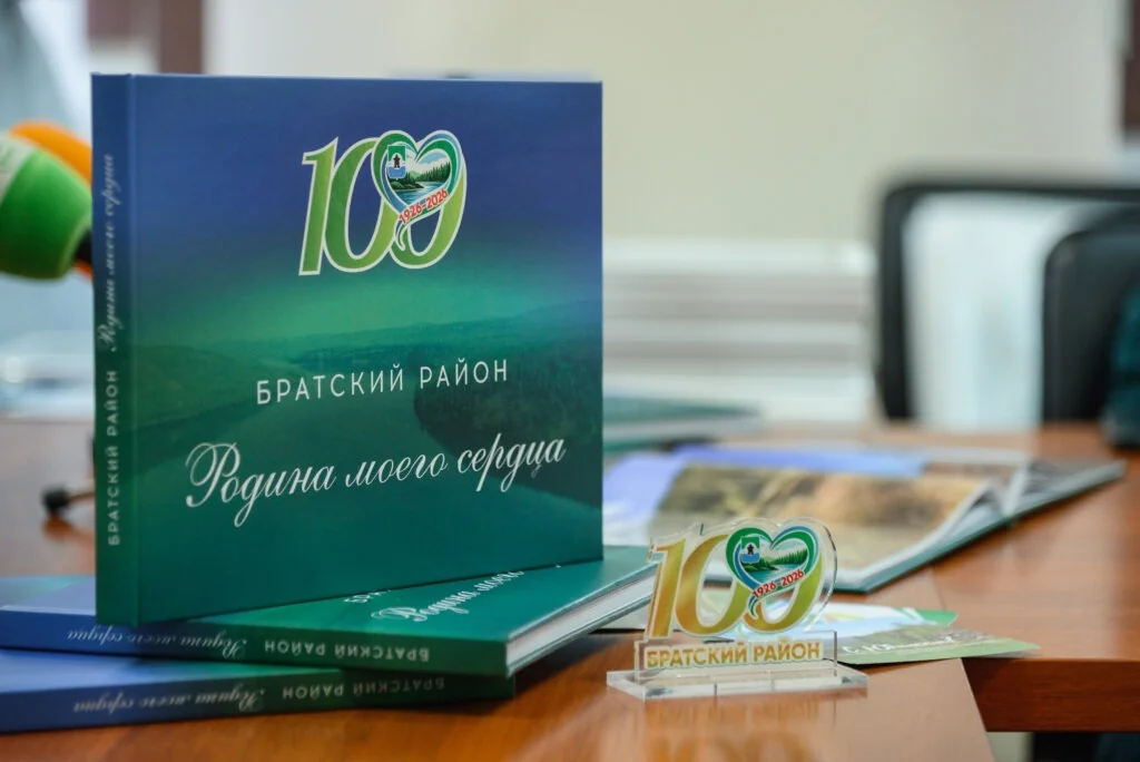
The centenary brought the photo book Bratsk District: Homeland of My Heart. The municipal announcement identifies journalist Nataliya Zakharova as the project’s creative author and records approximately four hundred photographs and a print run of 800 copies. Copies were intended for school and village libraries and the inter-settlement library collection, providing a practical direction for further reading.

Settlement-specific publications, including the Tem history, Tangui museum accounts and the Bratsk District: A to Z gazetteer, offer additional detail. A district chronicle connects events, while family archives restore their personal scale. Readers should enquire with libraries about availability: a small anniversary edition does not establish an open retail supply. Documents, identified photographs and names passed between generations continue the work of preserving district history.

The centenary publication at its 2026 presentation. The municipal announcement records a print run of 800 copies and approximately four hundred photographs.
2026

The district centenary photo book

The centenary publication at its 2026 presentation. The municipal announcement records a print run of 800 copies and approximately four hundred photographs.

Фотограф не указан / Photographer not identified · Администрация Братского района / Bratsk District administration
© правообладателя / rights reserved · Original ↗

Useful links

The largest towns and villages of Bratsk District ↗Bratsk District official website ↗Vikhorevka official website ↗Neighbourhoods within Bratsk city ↗Bratsk HPP history ↗Bratsk Reservoir ↗Angara Village ↗The Bratsk forts ↗Railways & stations ↗BLPK — Bratsk Timber-Industrial Complex ↗Zyaba: bay, beaches and dacha life ↗Bratskoye Vzmorye ↗Books about Bratsk and the Angara region ↗

Sources & further reading

Checked 19 October 2026. This article concerns Bratsk District in Irkutsk Oblast, separately from Bratsk city and its neighbourhoods. Population figures refer to 1 January 2025; the municipal profile was updated on 24 February 2026. Reform is described using the 2025 law and transitional provisions. Historical photographs, building dates and modern views are identified separately. Trip ideas require current access and transport information.