← Explore the cityBRATSK / PEOPLE & PLACES

Bratsk Reservoir.

The Bratsk Sea: how river valleys became an immense reservoir, what happened to flooded villages, and how the new shores developed. An extensive history of people, water and a changing landscape.

54 CHAPTERS / ABOUT 29 MIN READ
1961

1 September: filling begins

1967

Initial filling completed

5 470

km²: reference area at design filling

169.3

km³: full reservoir storage

Article contents

A sea made by people

Bratsk Reservoir began with a dam across the Angara, but it has become a world of its own: long open reaches, branching bays, islands, fishing places and villages on new shores. The local name “Bratsk Sea” conveys the experience of that space. From a broad stretch of shore, it is difficult to imagine the former river valley and roads connecting neighbouring settlements.

Its history belongs both to an enormous power station and to individual houses dismantled before inundation. Siberian electricity, travel patterns, fish communities and family memories all changed here. The story therefore begins well before the first full reservoir and continues beyond 1967. An artificial lake does not stop changing when initial filling is complete.
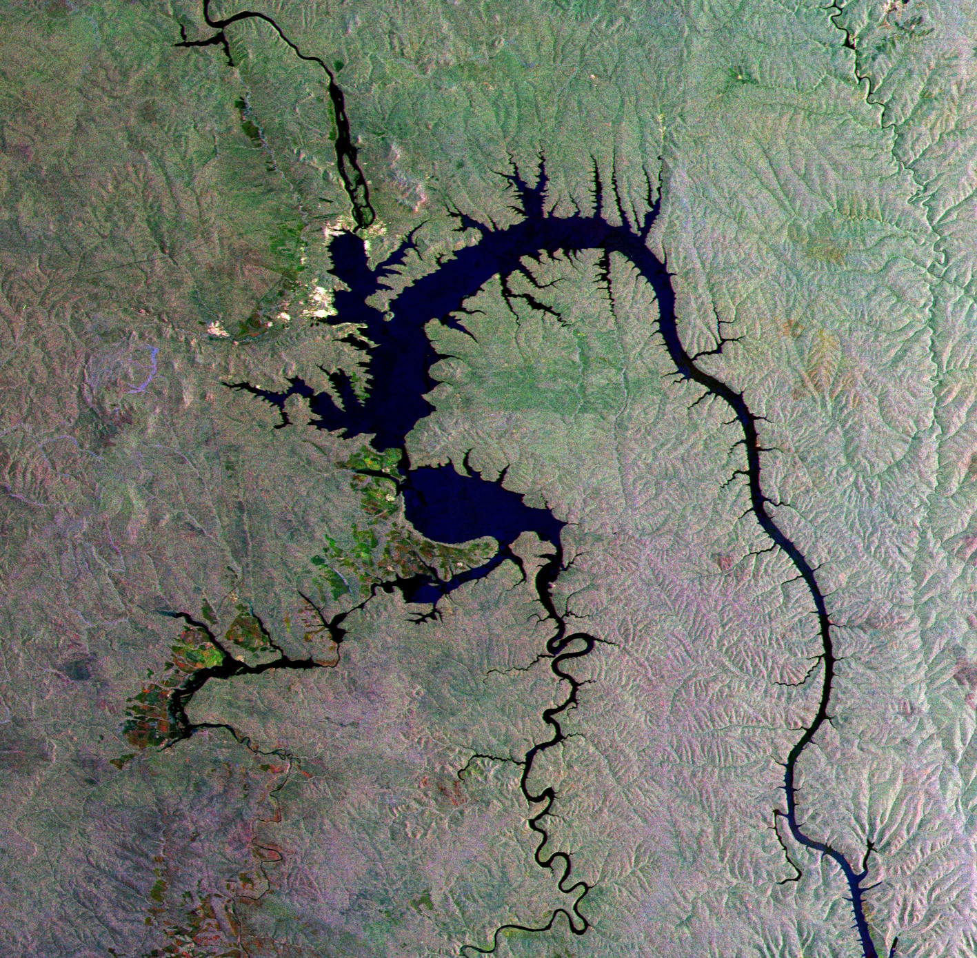
ESA’s radar image “Siberian gecko”, published on 17 December 2010. The branching outline follows inundated valleys. Colours reflect radar imaging and processing, rather than an ordinary natural-colour aerial photograph. Publication is not presented as the exact acquisition date.
≤ 2010

Bratsk Reservoir from Envisat

ESA’s radar image “Siberian gecko”, published on 17 December 2010. The branching outline follows inundated valleys. Colours reflect radar imaging and processing, rather than an ordinary natural-colour aerial photograph. Publication is not presented as the exact acquisition date.

ESA · ESA / Envisat
CC BY-SA 3.0 IGO · Original ↗
Why its outline looks alive

Satellite images reveal a branching figure. Narrow extensions follow river valleys, wider reaches occupy former low ground, and side bays penetrate far inland. This is not a regular bowl excavated along a single outline: impounded water occupied an existing landscape, preserving its structure in a new shoreline.

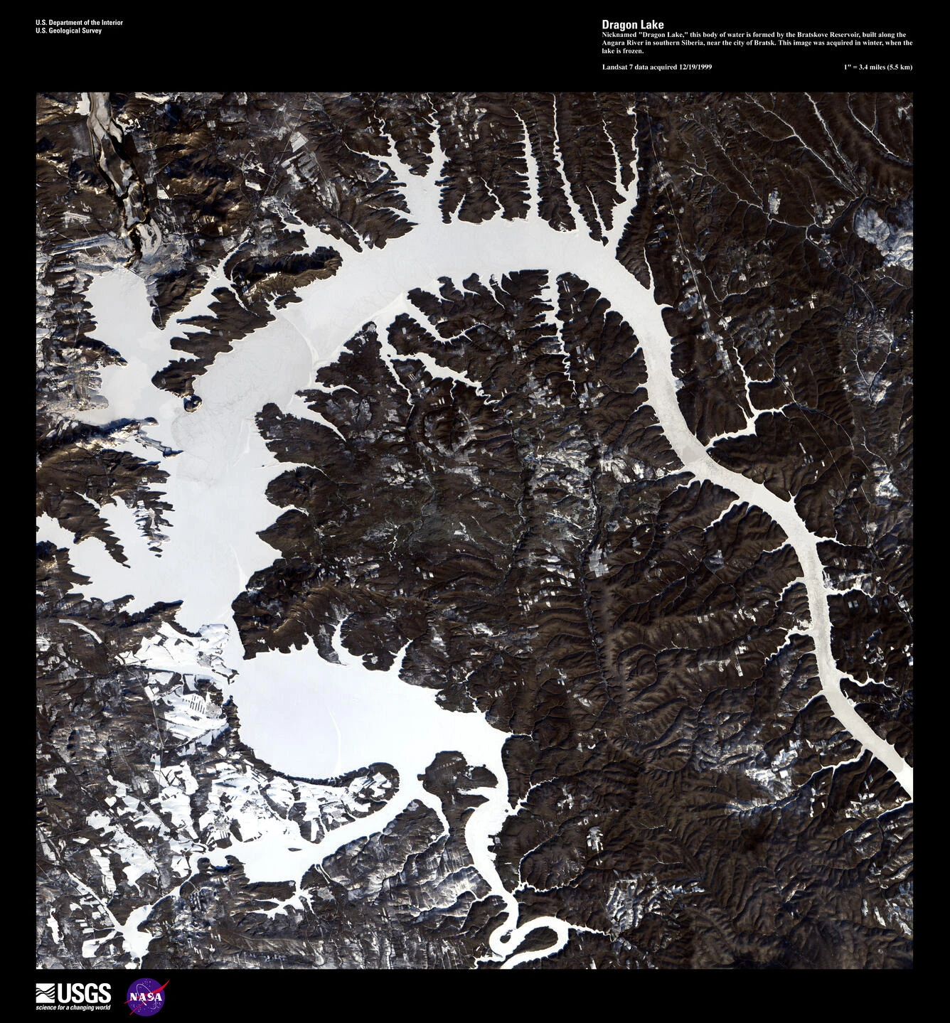
The European Space Agency called one Envisat image “Siberian gecko”, while the US Geological Survey used “Dragon Lake” for another view. These are imaginative publication titles rather than additional official place names. Radar imagery and a winter satellite view reveal a whole that no single viewpoint on the shore can encompass. Their appearance also depends on the sensor and the image processing.

Landsat 7 image in the USGS Earth as Art collection. The page carries 1 December 1999 and describes winter acquisition over the frozen reservoir. “Dragon Lake” is an imaginative collection title rather than an official local place name.
1999 · публикация / publication

Winter view: Dragon Lake

Landsat 7 image in the USGS Earth as Art collection. The page carries 1 December 1999 and describes winter acquisition over the frozen reservoir. “Dragon Lake” is an imaginative collection title rather than an official local place name.

USGS · US Geological Survey / Landsat 7
Public domain · Original ↗

Several river valleys beneath one reservoir

The reservoir's principal branches follow the Angara and the Siberian Oka, joined by tributary valleys and numerous bays. The Iya is another important river in this system. This Oka flows into the Angara; it is not the river of the same name in European Russia. The branching outline explains why distances along the shore, in a straight line and along a navigable channel can differ greatly.

Upper reaches retain more river-like conditions, whereas broad open reaches exchange water more slowly and behave more like a lake. Any statement about “the water in the Bratsk Sea” therefore needs a location. A small bay, a tributary mouth and an open reach can differ in current, warming and shoreline conditions on the same day.

Two different reservoirs beside Bratsk

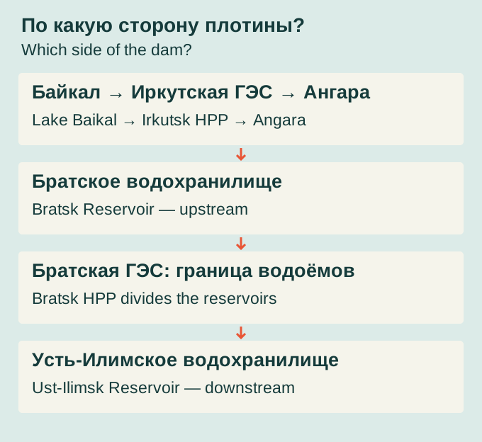
Bratsk Reservoir lies upstream of Bratsk HPP on the Angara. Below the dam is a different body of water: Ust-Ilimsk Reservoir, backed up by the next power station downstream. Consequently, not every photograph of water near Bratsk shows the Bratsk Sea. Views from the downstream side, Padun or Gidrostroitel may show the neighbouring reservoir.

Farther upstream are Irkutsk HPP and Lake Baikal. Baikal water enters the Angara, passes the Irkutsk hydraulic works and then supplies Bratsk Reservoir together with tributary inflows. The Angara eventually joins the Yenisei. The cascade connects these stations, but it does not turn their reservoirs into a single lake. Each has a distinct dam, inundation area and resettlement history.

Original flow-order diagram showing the two reservoirs relative to Bratsk dam. It represents neither scale nor distances and does not show the entire Angara cascade.
2026 · схема / diagram

Which side of the dam?

Original flow-order diagram showing the two reservoirs relative to Bratsk dam. It represents neither scale nor distances and does not show the entire Angara cascade.

bratsk.com · bratsk.com
CC BY 4.0 · Original ↗

5,470 square kilometres

The state reference card lists an area of 5,470 square kilometres and a full storage volume of 169.3 cubic kilometres. The area refers to a specified design filling condition, not an unchanging waterline in every season. As the level falls, shallow ground emerges, bays change outline and the actual surface area changes.

These figures are more useful than an unexplained global ranking. Rankings by area, total storage and regulating storage produce different results. Bratsk belongs among the great artificial reservoirs, but “second in the world” without a date and criterion explains little. Its dimensions describe an elongated water region extending far beyond the city, rather than a single broad bay immediately beside the dam.

Why total storage is not all usable

Full storage describes water throughout the filled basin. Flow regulation uses only the portion between prescribed operating levels; water remains in the deep basin during normal drawdown. Turning 169.3 cubic kilometres into a promise of available electricity or a fixed number of years of guaranteed water supply would therefore be misleading.

Actual operation depends on inflow, permitted levels, equipment and downstream requirements. The reservoir receives floodwater, releases it through turbines and spillway structures, and remains a setting for navigation, water intakes and living organisms. Its level reflects management of that combined system. It is not a simple indicator of whether one factory needs more or less electricity, nor a direct measurement of the generating station's output.

The Angara as road, livelihood and boundary

Before impoundment, the flowing river organised the landscape. Settlements followed its banks, linked by landings, crossings and winter routes. Residents knew the shallows, convenient moorings, floodplain gardens and hay meadows. The river supplied fish and transport while setting a seasonal rhythm of work.

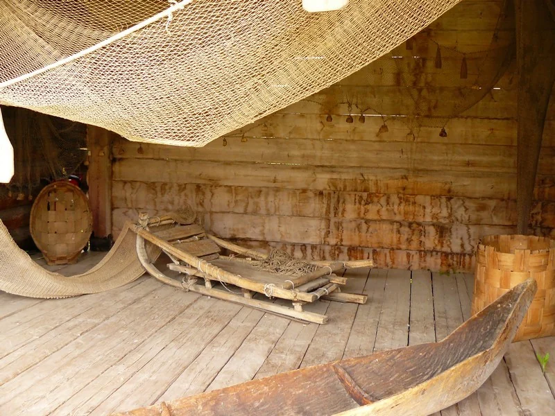
The new sea changed more than the width of the water. A short crossing could become an open reach, while a familiar road ended at a new bay. An old route description could become unintelligible to someone born after inundation. Museum boats, fishing gear, photographs and oral accounts help reconstruct that river geography: a world in which the Angara was not yet part of a large regulated reservoir.

River work in the museum display: a boat, nets and timber storage space.
б/д · undated

Boat and fishing equipment

River work in the museum display: a boat, nets and timber storage space.

Фотограф не указан / Photographer not named · Братский городской объединённый музей / Bratsk City Museum
© Bratsk City Museum · официальная музейная публикация / official museum publication · Original ↗

An inhabited valley

The future reservoir bed was not an empty space between forest and river. It contained old villages, farmland, schools, institutions, cemeteries and industrial settlements. Balagansk's history reached back to a seventeenth-century fortress, while Bratsk also originated as an Angara stronghold. Other village names are now familiar mainly to descendants of displaced families.

On a map, a settlement is a label. For a family, it comprised a parent's house, a neighbour's yard, the school road and a hay meadow. Both scales matter. A large hydraulic project transformed thousands of square kilometres, but people experienced that transformation through individual homesteads. Keeping a village name at a new location did not preserve the original settlement in place.

The dam and its future sea developed together

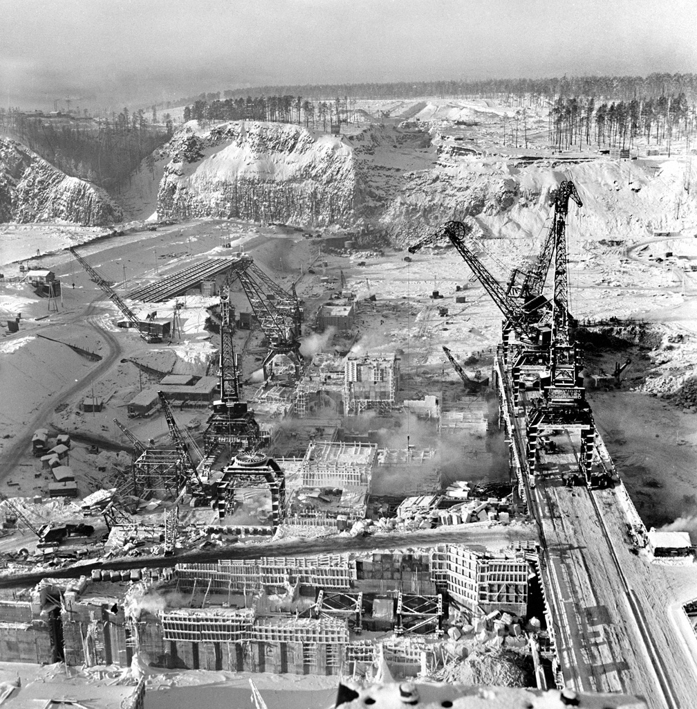
Building Bratsk HPP meant working across two enormous sites. One was concentrated around the future dam: excavation, concrete, transport and installation. The other extended through river valleys, where preparing the future reservoir required land surveys, building assessments and new locations for settlements.

Public memory more readily retained cranes and the first turbines. Yet without relocating homes, roads and institutions, filling the basin would have directly endangered residents. The city chronicle and resettlement research reveal these parallel processes. Progress at the dam brought rising water closer to old villages. For a household, the decisive deadline might be the day it had to leave its home rather than the commissioning of a generating unit.

1 February 1960. The Bratsk dam construction site.
1960

Building the Bratsk hydroelectric station

1 February 1960. The Bratsk dam construction site.

Макс Альперт / Max Alpert · РИА Новости / RIA Novosti, № 791507
CC BY-SA 3.0 · Original ↗

Assessment commissions arrive

The local library study of Angarsky links resettlement preparations to USSR Council of Ministers Decree No. 389 of 1956. Local commissions assessed private houses and outbuildings, determining value, suitability for relocation and the work to be documented.

Behind the administrative procedure lay a difficult conversation about a family's future. Owners needed to understand what would happen to their house, where it could be moved and what assistance they could expect. Different structures received different assessments. A commission's decision separated belongings that would enter a new life from structures left in the inundation zone. These assessment records now matter as inventories of vanished domestic life as well as financial documents.

What happened to the forest

Preparing the basin included felling forest and clearing structures and other objects that could interfere with operation. Complete clearance of such an enormous branching territory proved impossible. The local history of Tangui explicitly records unfinished clearance; wooded areas and timber remained underwater.

This was more than a striking early image of trunks standing in rising water. Submerged wood became part of the bottom environment, affected use of the reservoir and created obstacles for navigation and fishing gear. Modern hydroacoustic surveys still distinguish flooded forest in their echograms. Traces of the previous landscape can therefore persist far longer than the initial filling period, even after the visible shoreline has acquired an apparently established, natural appearance.

Filling begins

The city chronicle dates the start of filling Bratsk Reservoir to 1 September 1961. Closing the dam's low-level openings allowed the upstream water level to rise. The first generating units entered service that autumn: creating hydraulic head and producing electricity were connected stages of the same project.

Water did not cover the entire future surface in a day. Its advance depended on ground elevation and the gradual rise in level. Some settlements faced an earlier deadline than others. Familiar landmarks were already disappearing in one place while buildings were still being moved and land cleared elsewhere. That uneven progression helps explain why memories from different villages preserve different dates and images of the sea's arrival.

Six years of emerging shores

Filling continued until 1967. That makes the reservoir's history different from the ceremonial moment of blocking the river: its future shoreline formed gradually. Water entered side valleys, changed the relationship between mainland and islands, approached higher ground and covered former roads.

At the same time, new settlements developed, generating capacity entered service and connections between districts changed. The official operating year of 1967 does not mean that every associated problem ended then. Work on resettlement villages and observation of eroding shores continued afterwards. The sea already existed on the map while its inhabited banks still needed roads, public facilities and a dependable everyday life. Initial filling was a milestone in a longer transformation.

How many villages had to be left

Galina Yankovskaya's 2021 study, citing Yury Ryabov, identifies approximately a hundred villages and 16,200 individual households in twelve districts within the Bratsk HPP inundation zone. These are households, not 16,200 people. A family could include several members, while different records counted private homesteads, public buildings and settlements using different categories.

Local histories may give other totals for a particular district or phase of relocation. Adding them together is unsafe because areas and counting units overlap. Preserving the scope of each count is more reliable. The enormous scale is clear, but an approximate village count should not be converted into a supposedly exact total of displaced residents.

A house in an assessment record

The Angarsky library study reproduces an assessment record for Alexander Timofeyevich Kravtsov's property in Muchnaya Step. It lists structures and work values; the researcher separately identifies allowances for dismantling and transport. Behind those formal entries lies an entire homestead that could not be moved in a single operation.

Such records make specific questions possible: what was assessed, which tasks fell to the owner, and how long passed between valuation and departure? One record does not prove that every displaced household received identical support. Instead, it demonstrates why local circumstances matter. For family researchers, it can preserve a material trace of a home that no longer exists on its original riverbank.

Moving a log house was only the beginning

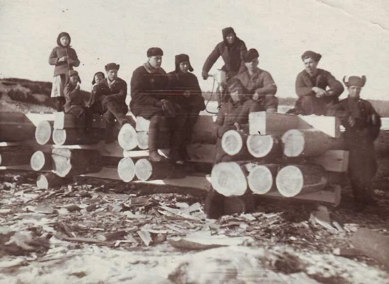
A timber house could be dismantled, transported and rebuilt. A homestead also included a bathhouse, barn, livestock shelter, fences, stores and tools. At the new location, families needed access, water, heating and space for animals. These ordinary tasks could take months and determined whether relocation became a manageable change of address or a severe disruption.

Published Tangui recollections describe shortages of materials, delayed payments and temporary stays with neighbours or in adapted outbuildings. These are particular witnesses' experiences rather than a universal biography of every household. They restore duration to resettlement: between an assessment decision and a habitable yard lay labour, waiting, family assistance and continuing expense.

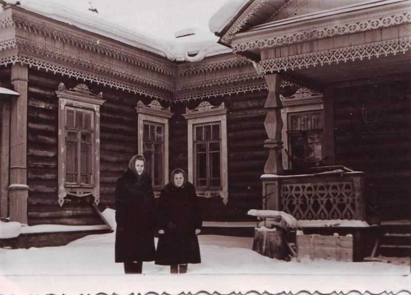
Group photograph beside timber construction in the account of old Tangui and relocation. Participants and the exact shooting date are not supplied. It is not presented as a precisely dated record of dismantling or moving a specific house.
б/д · undated

People and a log structure: the Tangui archive

Group photograph beside timber construction in the account of old Tangui and relocation. Participants and the exact shooting date are not supplied. It is not presented as a precisely dated record of dismantling or moving a specific house.

Автор не указан / photographer not identified · Музей с. Тангуй / публикация Елены Шевкуновой на сайте Братского района
© правообладателя / rights reserved · Original ↗

Homes also needed schools

Moving a population required more than residential streets. Children needed schools, patients needed medical care, and households needed shops and transport. Tangui's history shows public services occupying transferred buildings, changing premises and operating while the new village was still being built.

Relocation did not always improve conditions immediately. An attractive old timber building might function poorly as classrooms, and scattered premises complicated teaching. Recollections should be read alongside construction records: one reveals everyday difficulties, the other the facilities specified in a project. The difference between a completed building and a fully functioning institution is especially visible on the new shores. A school signalled that a settlement was beginning a life extending beyond a single building season.

The source identifies the outpatient-clinic building as transferred from old Tangui. Its carved details preserve the material history of public buildings that survived relocation. The shooting date is not established.
б/д · undated

The outpatient-clinic building moved from old Tangui

The source identifies the outpatient-clinic building as transferred from old Tangui. Its carved details preserve the material history of public buildings that survived relocation. The shooting date is not established.

Автор не указан / photographer not identified · Музей с. Тангуй / администрация Братского района
© правообладателя / rights reserved · Original ↗

Burial places had no simple new address

Displacement affected relationships with the dead as well as the living. A cemetery connected families with several generations, making departure especially painful. Material on old Tangui preserves recollections of burial grounds damaged by advancing water. This is among the most difficult layers of local memory.

Such testimony should not become a sensational legend about an “underwater city”. An account of a particular cemetery needs a place, date and source. Changing levels and shoreline erosion can expose traces of the past again; discoveries call for respectful treatment and notification of the appropriate local authorities. For descendants, these are not exotic attractions but relatives' histories that resettlement could not transfer in their entirety.

The name remained; the place changed

Old Bratsk beside the Angara and the modern industrial city should not be imagined as one continuously developed site. Construction and impoundment transformed the former settlement's setting, while urban life shifted towards new districts. Historical photographs consequently need explanation: their riverbank may no longer exist in its former shape.

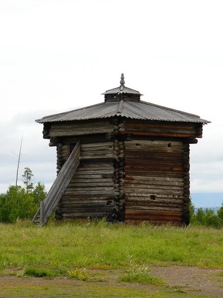
Surviving fortress towers became particularly important material witnesses. They offer more than an abstract image of “Bratsk before the dam”: they are actual structures transferred from the old landscape. Their dating and restoration histories are themselves complex. The separate account of Bratsk's fortresses connects the reservoir with earlier centuries, preventing the city's entire history from being reduced to the start of industrial construction.

The southwest tower at Angara Village. A 2026 study dates the surviving towers to 1685, revising the traditional museum date of 1654.
б/д · undated

An original Bratsk Ostrog tower

The southwest tower at Angara Village. A 2026 study dates the surviving towers to 1685, revising the traditional museum date of 1654.

Фотограф не указан / Photographer not named · Братский городской объединённый музей / Bratsk City Museum
© Bratsk City Museum · официальная музейная публикация / official museum publication · Original ↗

A name that outlived the rapids

Padun belongs to the history of the old Angara, its rapids and an earlier settlement. Hydroelectric construction transformed that setting, while the name survived within the new city. Accounts may therefore mention old Padun, today's district and the dam together even though these are different places and periods.

Visitors need to distinguish a name's history from its present map location. Looking for old Padun is not the same as walking the streets of the modern district. Water below the dam also belongs to Ust-Ilimsk Reservoir. The example shows how impoundment can transform geography while leaving familiar words in use: a name survives after the original landscape, road and river conditions have changed.

A village still visible in photographs

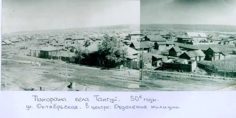
Tangui's village museum and local researchers have assembled a detailed history of the old settlement. Elena Shevkunova's account combines archival material with residents' recollections. A village panorama, public buildings, group portraits and a street plan survive. They show an inhabited place rather than a dot on an inundation plan.

Captions are essential: where an institution stood, which building acquired another use after relocation, and what a street was called. Without that information, even a striking photograph soon becomes an anonymous “old village”. The 1950s panorama reveals the pattern of houses and neighbouring yards. It offers a visual starting point for comparison with the new Tangui, which occupies a different site.

Archival panorama identified as Tangui in the 1950s in the municipal publication. Timber buildings and a village street are visible. Old and new Tangui occupy different sites.
1950-е · 1950s

Panorama of old Tangui

Archival panorama identified as Tangui in the 1950s in the municipal publication. Timber buildings and a village street are visible. Old and new Tangui occupy different sites.

Автор не указан / photographer not identified · Музей с. Тангуй / администрация Братского района
© правообладателя / rights reserved · Original ↗

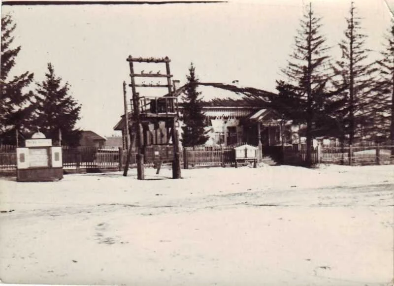
Public building in the old village centre. The publication associates it with the district party committee; its caption and account trace institutions affected by relocation. The exact photograph date is not supplied.
б/д · undated

The public centre of old Tangui

Public building in the old village centre. The publication associates it with the district party committee; its caption and account trace institutions affected by relocation. The exact photograph date is not supplied.

Автор не указан / photographer not identified · Музей с. Тангуй / администрация Братского района
© правообладателя / rights reserved · Original ↗

How new Tangui began

Published recollections describe the first builders travelling roughly four kilometres from the old village to the new site. Fyodor Shalyga, responsible for work in the inundation zone, helped mark streets and allocate plots. The new village first existed as a plan and then had to be created in actual forest terrain.

The first wells illustrate the distance between design and daily life. Streets and homesteads already existed on paper, but residents still needed water. Witnesses remembered wells on Koshevogo and Suvorova streets, the earliest households and a communal bathhouse. Relocation thus consisted of many small tasks, each making the new site a little more suitable for permanent settlement.

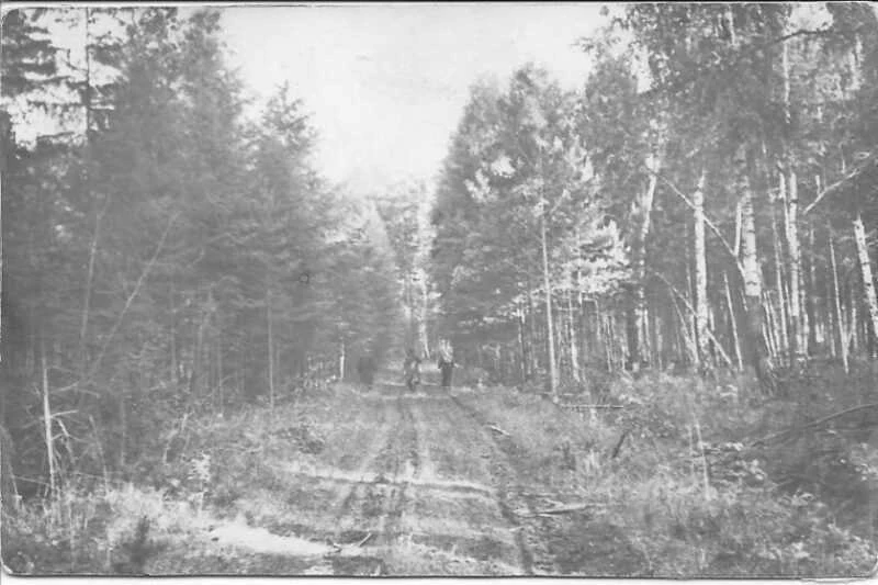
Archival photograph captioned “The road to new Tangui”. The forest track evokes the early development of the new site; the source does not identify the exact year or people pictured.
б/д · undated

The road to new Tangui

Archival photograph captioned “The road to new Tangui”. The forest track evokes the early development of the new site; the source does not identify the exact year or people pictured.

Автор не указан / photographer not identified · Музей с. Тангуй / администрация Братского района
© правообладателя / rights reserved · Original ↗

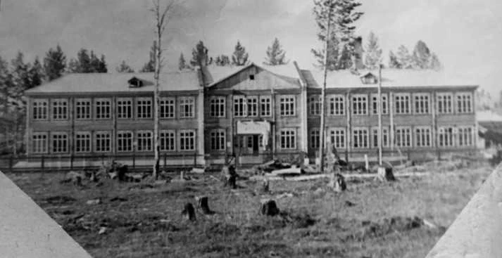
A new school before the rising water

A 1960 archival photograph shows a two-storey school under construction in new Tangui. The local chronicle dates its opening, with 240 places, to 1 September 1961. Its coincidence with the start of reservoir filling connects two scales of history: a vast hydraulic project and children's first school day at their new location.

The school did not remain an enduring relocation monument: the local account records that it burned down in 1989. The photograph therefore preserves more than a building stage. It shows a place that became familiar to a generation of pupils and later disappeared itself. Life in the resettled village continued, acquiring further losses, changes and replacement buildings.

1960: the two-storey school under construction. The local chronicle dates its opening, with 240 places, to 1 September 1961. This is the new village, not a building at the site destined for flooding.
1960

Building the school in new Tangui

1960: the two-storey school under construction. The local chronicle dates its opening, with 240 places, to 1 September 1961. This is the new village, not a building at the site destined for flooding.

Автор не указан / photographer not identified · Музей с. Тангуй / администрация Братского района
© правообладателя / rights reserved · Original ↗

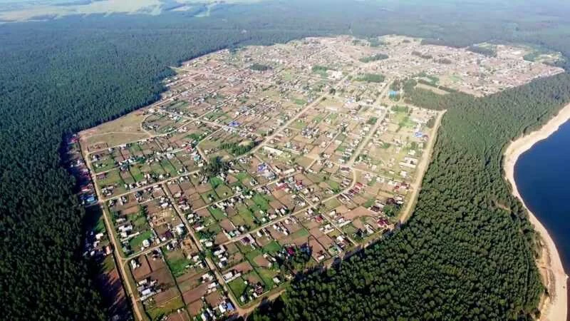
The new village became home to later generations

Tangui's 2022 aerial photograph shows an established village: a street network, many homesteads, forest and the shore of a large reservoir. It no longer resembles the temporary building site it once was. For people born there, these streets became their home, even where family memory still points towards another riverbank.

Old and new Tangui should be compared as different sites connected by people and a name. The photographs are not before-and-after views from one identical position. Together they show rupture and continuity: the former location left everyday life, while names, some buildings, families and stories survived. This acknowledges displacement without denying the new village a substantial history of its own.

2022, according to the source caption. The relocated village has streets, homesteads, forest and a reservoir shore. It is not a repeat view from the same position as the old Tangui panorama.
2022

New Tangui from above

2022, according to the source caption. The relocated village has streets, homesteads, forest and a reservoir shore. It is not a repeat view from the same position as the old Tangui panorama.

Автор не указан / photographer not identified · Музей с. Тангуй / администрация Братского района
© правообладателя / rights reserved · Original ↗

Russky Nelkhay and Muchnaya Step: choosing a new site

Angarsky's library history preserves the local relocation story of Russky Nelkhay and Muchnaya Step. Several possible sites were discussed: access made one difficult, while another stood farther from the river. The eventual choice was higher ground previously used as a collective-farm maize field, where the future blocks were laid out.

The study names Alexander Petrovich Shulgin, who worked on the plan and the inundation zone in Alarsky District. Alongside administrative decisions are residents' recollections of disbelief that water would arrive soon. This local account matters because the sea did not develop through an identical sequence everywhere. Each new site had its own terrain, responsible people, disagreements and timetable.

An old town and a new settlement

Balagansk is one of the most prominent historical places associated with inundation. Its official local history traces the settlement to a fortress founded in 1654 and records town status in 1775. Rising water transformed its fate, while the name continued at a new location.

Relocation separated historical topography from present addresses. Old descriptions of streets, public buildings and riverside landmarks cannot simply be overlaid on today's plan. Some material heritage was transferred; the administration describes a nineteenth-century school building given a place in the new settlement. Balagansk demonstrates why the reservoir's memory extends far beyond Bratsk: it changed a whole chain of Angara communities with long histories of their own.

A writer's life along the reservoir

Ust-Uda and Atalanka connect the Bratsk Sea with Valentin Rasputin. The writer spent his childhood in old Atalanka, and the displacement of Angara villages became a central subject of his fiction and public reflection. Here the difference between a surviving name and a lost place is particularly clear.

His museum approaches the subject through biography, manuscripts and objects as well as the famous novella. The fictional village of Matyora is not an exact plan of Atalanka or any other single settlement. Historical inundation and a literary image are connected but are different kinds of evidence. Today's Ust-Uda and Atalanka remain inhabited communities with their own lives, rather than scenery for one literary work.

Rescuing what could not remain in place

Hydroelectric development made archaeological and timber-architecture research in the Angara region especially urgent. Rescue investigations and museum transfers preserved some objects, but could not replace an entire landscape. An individual object could survive inundation while its relationship with neighbouring structures, roads and riverbank had to be reconstructed.

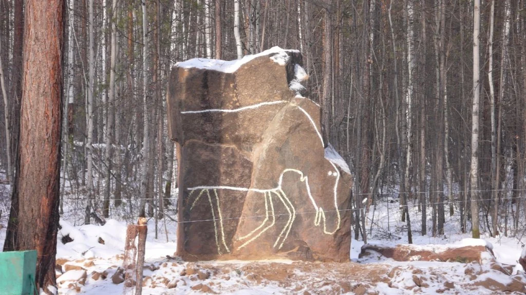
Angarskaya Derevnya displays material witnesses, including a rock bearing a petroglyph. Each object's origin nevertheless needs separate attention. The museum collected from different places, and the later Ust-Ilimsk dam created another inundation zone. Attributing all rescued heritage to Bratsk Reservoir would be incorrect. A museum label matters more here than the general impression created by an old-looking object.

A salvaged rock-art fragment displayed at the museum. A pale outline makes the figure easier to see in this photograph; the museum estimates the image at 5,000–8,000 years old.
б/д · undated

A rock bearing an elk image

A salvaged rock-art fragment displayed at the museum. A pale outline makes the figure easier to see in this photograph; the museum estimates the image at 5,000–8,000 years old.

Фотограф не указан / Photographer not named · Братский городской объединённый музей / Bratsk City Museum
© Bratsk City Museum · официальная музейная публикация / official museum publication · Original ↗

Houses on dry land tell the pre-reservoir story

The open-air museum makes the scale of a homestead tangible: house, outbuildings, crafts and river occupations. After immense area and storage figures, it returns the story to human dimensions. Such details explain why transferring one dwelling did not preserve an entire way of life.

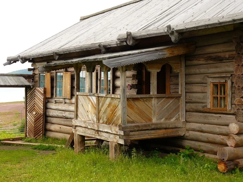
The museum is not a full-scale reconstruction of a single flooded village. Its exhibits have varied origins, so its arrangement should not be treated as an exact copy of old Bratsk or Tangui. Comparing objects with photographs and documents reveals both what was rescued and what lost its original setting. A visit complements a shoreline walk by restoring people, buildings and everyday work to the view of the great reservoir.

A dwelling in the Russian sector. The museum album does not identify the homestead or the date of the photograph.
б/д · undated

A house with a porch

A dwelling in the Russian sector. The museum album does not identify the homestead or the date of the photograph.

Фотограф не указан / Photographer not named · Братский городской объединённый музей / Bratsk City Museum
© Bratsk City Museum · официальная музейная публикация / official museum publication · Original ↗

Farewell to Matyora: literary memory

Valentin Rasputin's Farewell to Matyora, first published in 1976, became a major literary response to the inundation of village life. Its focus is not a dam's engineering specifications but people's relationships with home, ancestors and land that cannot simply be discarded.

Reading it alongside Bratsk Reservoir's history is illuminating, but fiction cannot replace an archive. Matyora is a literary setting, and its characters and events do not constitute an official record of one village's relocation. Documents reconstruct dates, decisions and property; literature explores the moral conflict. Together they offer a fuller account than either a triumphant construction chronicle or a list of lost settlements alone.

Songs also cross the water

The old Angara region survives in more than buildings and books. In 2019, Rasputin's museum reported a performance by an authentic-music ensemble and Alexander Rogachev's Flooded Songs project. Its collected repertoire restores something of the sound of a world transformed by hydroelectric construction.

For resettlement history, this is a distinctive kind of evidence. A song could travel without a truck, but performing it depended on people, neighbours and shared occasions. The loss of a village changed that setting too. A recorded voice and an account of who sang and when can complement a house photograph. Reservoir history thus becomes cultural history, continuing after the original place is lost and sometimes far from the new shores.

Why the power station needs stored water

A hydroelectric station converts the energy of falling water into electricity. The reservoir creates hydraulic head and redistributes river flow over time: not all water arriving during a wet period must pass through immediately. Within permitted operating conditions, this gives the electricity system flexibility in scheduling generation.

Bratsk HPP became a foundation of regional industrial development, including aluminium and forest-chemical production. The sea is nevertheless not a private storage tank for one enterprise. The station operates within an interconnected power system and a cascade of hydraulic works. Understanding the reservoir's role requires considering capacity, inflow, regulating storage and network connections together, rather than only the dam's impressive dimensions or turbine count.

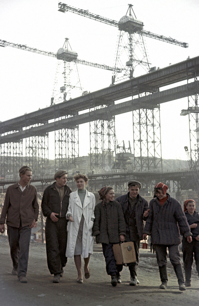
1 March 1960. Builders at the Bratsk dam.
1960

The people who built it

1 March 1960. Builders at the Bratsk dam.

Алексей Бушкин / Alexey Bushkin · РИА Новости / RIA Novosti, № 699661
CC BY-SA 3.0 · Original ↗

One reservoir, several purposes

Saving water for dry conditions, maintaining downstream flows, supporting intakes and navigation, and generating electricity do not always favour the same level. Operating a large reservoir therefore involves inflow forecasts and competing water-use requirements.

Residents experience the outcome directly: water approaches a boat ramp or retreats from it. Behind that change is a balance of volumes and constraints. Explaining every drawdown solely as a desire to sell more electricity, or every high-water period solely through rain in Bratsk, overlooks the wider catchment and neighbouring hydraulic works. Local inconvenience remains real and deserves attention even where an operating decision has a system-level technical explanation.

Why a familiar beach can change

On a gentle shore, a level change can move the waterline a long horizontal distance; against a steep slope, it is more apparent vertically. The same drawdown consequently looks different in different bays. Broad strips of exposed ground appear, access points shift and depths around familiar stopping places change.

Normal retention level is a design reference, not a promise of a fixed surface. Daily values should come from current hydrological reports with their stated vertical datum. Comparing numbers from different references without checking that datum can create apparent contradictions. For a visit, confirming access and a particular launch site is more useful than relying on an attractive photograph of the same shore in another season.

Open reaches can develop serious waves

Long open water gives wind room to build waves. A sheltered bay and an adjacent broad reach can feel like different bodies of water: one may be almost calm while a small boat already struggles in the other. Shore relief and wind direction produce different conditions even at nearby locations.

The sea nickname has a practical meaning here. The absence of ocean tides does not make an artificial reservoir reliably calm. Any trip needs a forecast, a clear understanding of the route and a way to return if conditions deteriorate. A short line on the map does not guarantee a short safe crossing. A shoreline walk or an organised outing with an experienced local operator is a better first introduction.

Freeze-up does not happen everywhere at once

Winter transforms the Bratsk Sea, but does not turn it into a uniform ice platform. Depth, currents, wind and tributary inflows influence freezing and breakup. A sheltered bay may look established while open water or a current-affected section has very different conditions.

Historical freeze-up dates in a reference book are not permission to venture onto the ice in a particular year. Current local information and officially checked routes are needed. A winter satellite view reveals the reservoir's general outline, not the thickness or strength of ice beneath a person's feet. Spring can be especially deceptive: a surface that remains visually intact may already have lost its bearing strength, as actual emergency-service reports demonstrate.

The sea keeps reshaping its boundary

Once filled, the reservoir met ground that had not previously been the shore of a large lake. Waves undermine slope bases, and collapses move the land edge inland. Level fluctuations, geological material and shoreline shape determine where change proceeds fastest. A line on an old map may therefore differ from today's stable edge.

Erosion affects roads, property and traces of earlier settlement. During the early decades, inundation-zone services monitored such processes; the Tangui history records this responsibility for the district office. For a walk, a high bank is best viewed from a safe distance, away from overhanging edges and undercut slopes. A picturesque appearance does not establish stability.

A new waterway with its own limits

The reservoir created long deep-water reaches and new transport opportunities while changing the old network of landings. Cargo moved by water, tugboats worked and service craft operated. Branching shores gave some villages a water connection where overland travel was lengthy or difficult.

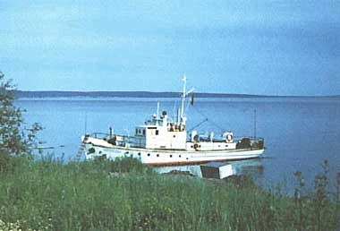
Bratsk HPP has no navigation locks. A normal uninterrupted river service cannot simply pass through its dam from one reservoir into the next. The Bratsk Sea is a separate navigation pool with its own routes and constraints. A research-vessel photograph in the ILEC database illustrates another aspect of navigation: the water became a setting for measurement, observation and scientific expeditions as well as industrial freight and passenger journeys.

Photograph by I. N. Varfolomeeva in the ILEC scientific database: the reservoir shore and a research vessel. No shooting date is provided. The image accompanies a historical limnological dataset, not a report of a 2026 voyage.
б/д · undated

A research vessel by the shore

Photograph by I. N. Varfolomeeva in the ILEC scientific database: the reservoir shore and a research vessel. No shooting date is provided. The image accompanies a historical limnological dataset, not a report of a 2026 voyage.

I. N. Varfolomeeva · ILEC World Lake Database / И. Н. Варфоломеева
© правообладателя / rights reserved · Original ↗

Balagansk–Igzhey and life between shores

The East Siberian River Shipping Company's ferry page lists Balagansk–Igzhey. Such connections serve more than tourists: they support everyday travel, vehicles, supplies and work between settlements. Broad water can shorten one journey by boat while lengthening another by road.

Passenger lines and ferries depend on the navigation season, water levels, weather and vessel condition. Schedules need checking for the actual travel date; a route's historical existence does not guarantee a departure. The same applies to the Balagansk–Bratsk direction appearing in the operator's material. Before planning a connection, confirm the landing, vehicle or luggage arrangements and a return option. This article deliberately does not freeze a seasonal timetable into a permanent promise.

The dam, railway and timber cargoes

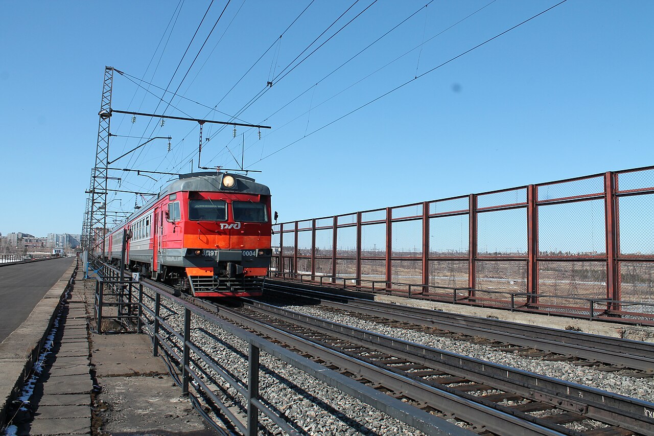
The hydraulic works reshaped Bratsk's transport geography. The crossing along the dam connected the banks, and trains became part of its recognisable appearance. Bratskoye More railway station is nevertheless a railway location, not a universal address for any beach; transport and reservoir names should not be confused when planning a visit.

Forest industries also used the new water system. Timber transport, towing and shore facilities connected the sea with regional enterprises. Methods and volumes changed over time, however. A historical account of timber rafting does not mean that the same operation exists in every bay today. The reservoir belongs in a picture that also includes roads, railway lines and industrial sites.

7 April 2016. Train on the dam crest. A later photograph of equipment and structures, rather than a construction-era image.
2016

Train on the dam crest

7 April 2016. Train on the dam crest. A later photograph of equipment and structures, rather than a construction-era image.

Сайга · Wikimedia Commons
CC BY-SA 4.0 · Original ↗

From a river to a mixed aquatic system

Regulation changed current speeds, depths, seasonal warming and the distribution of habitats. River-adapted species encountered different conditions, while species able to use slower water gained space. The new reservoir did not simply reproduce the old Angara on a larger scale; it developed a different ecosystem.

Upper reaches and tributaries retained flowing-water habitats, while deep reaches acquired lake-like features. Fish research shows that these differences still structure aquatic communities decades after filling. Accounts of fishing “before the sea” can consequently differ markedly from present catches. They describe environmental and community change rather than necessarily proving that a family's recollection is mistaken.

Warm surface, cold depths

During the warm season, deep water can stratify: the upper layer warms while colder water remains below. A thermocline, where temperature changes rapidly with depth, separates them. The fish study published in 2025 treats this layering as an important factor in species distribution.

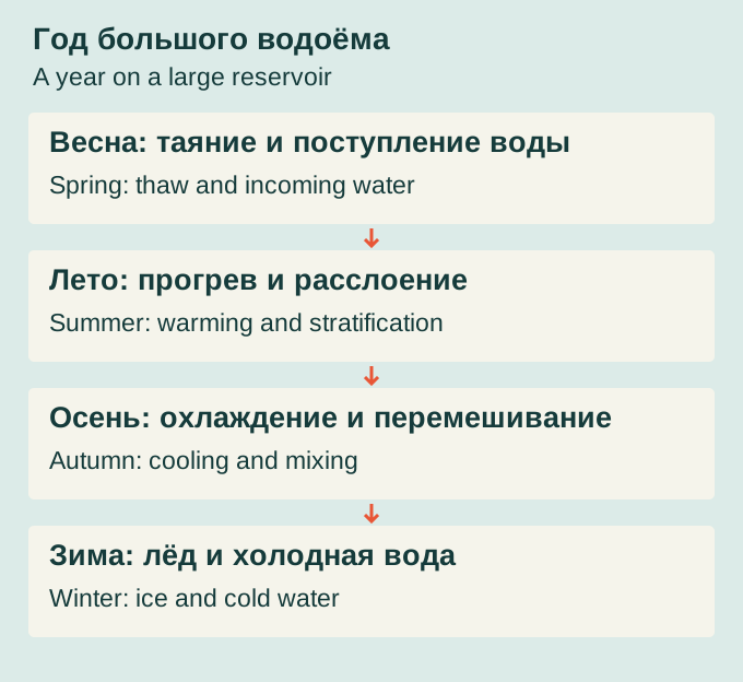
For swimmers, shoreline temperature does not describe the entire reservoir. For researchers, contrasting layers help explain why fish occupy particular depths. Wind, mixing and season modify the structure. Autumn cooling weakens the contrast before winter conditions develop. A summer description at one point therefore cannot represent the whole year. The reservoir follows a seasonal cycle while containing different thermal environments at the same time.

Original simplified seasonal overview. Timing and conditions differ by location and year; the diagram gives neither safe ice dates nor a fixed water-level schedule.
2026 · схема / diagram

A year on a large reservoir

Original simplified seasonal overview. Timing and conditions differ by location and year; the diagram gives neither safe ice dates nor a fixed water-level schedule.

bratsk.com · bratsk.com
CC BY 4.0 · Original ↗

What hydroacoustic surveys revealed

Yury Gerasimov and co-authors used hydroacoustic equipment to examine fish distribution in river-like and lake-like parts of Bratsk Reservoir. Their work was published in 2025. European perch stands out among abundant species, with roach and bream also important. Cold-water whitefishes use a different part of the water column from many warm-water species.

The central finding is the reservoir's heterogeneity. Species, depth, temperature and current are connected. One fishing spot cannot represent the entire water body. Echograms reveal distribution below the surface, but a scientific survey does not promise a successful catch at a named location. It explains an ecosystem rather than supplying a commercial fishing guide.

Stocking and responsible fishing

Young fish are released into Bratsk Reservoir through aquatic-resource reproduction programmes. Fisheries-agency reports for 2025 cover such work across Irkutsk Region. When reading combined totals, it matters whether a figure concerns Bratsk alone or several water bodies.

The number released does not equal a future adult population: survival and habitat conditions shape the outcome. Recreational fishing also has rules. Closed seasons, restricted areas, gear requirements and species limits should be checked through current Angara–Baikal fisheries information. An old account of plentiful fish or a private guide's offer cannot replace those requirements. Protecting the reservoir involves both habitat condition and compliance with the rules governing its resources.

How to read water-quality findings

Roshydromet's review for 2025 classifies 62% of Bratsk Reservoir monitoring cross-sections as conditionally clean, 31% as slightly polluted and 7% as polluted. These are proportions of surveyed cross-sections, not percentages of water volume or surface area. They do not mean that exactly 7% of the reservoir is polluted.

Conditions at a particular location depend on sampling place, date, measured substances and local influences. Industrial history, tributaries, inhabited shores and natural processes all matter. The review is not permission to swim anywhere or drink untreated water. Those decisions require current information for the actual location. Equally, one reported exceedance should not automatically be extended to the entire enormous reservoir.

Blooms visible from space

On 30 June 2026, Roshydromet published satellite observations for 24–29 June. They identified blue-green algal blooms during the month's final ten-day period, associated with warm water and slow circulation in bays. The bulletin specifically names Dolonovka, Oka and Iya bays, together with Unga and Zalari.

Satellite monitoring reveals spatial patterns and compares areas difficult to visit quickly by field expedition. Image-based chlorophyll estimates nevertheless do not replace laboratory examination of an individual sample or automatically determine bathing safety. This is an important contemporary chapter in the reservoir's story: ecological processes vary seasonally, while newer observation methods reveal conditions over an area much greater than a single shoreline station.

Forest, open water and a new shore zone

Forest against broad water is one of the Bratsk Sea's most recognisable views. Today's shoreline nevertheless formed after impoundment: former slopes became a coastal zone, while new shallows, cliffs and beach strips appeared. Vegetation adapts to waves, fluctuating levels and local soils.

In some places trees stand close to the water; elsewhere a broad strip of exposed ground separates them from it. This pattern changes with season and level. Outdoor recreation depends on care for that narrow shoreline environment: litter, fire sites and vehicles reaching the water can quickly alter an attractive place. The reservoir's immense size does not mean that every convenient stopping place can absorb unlimited pressure.

The sea beside everyday Bratsk

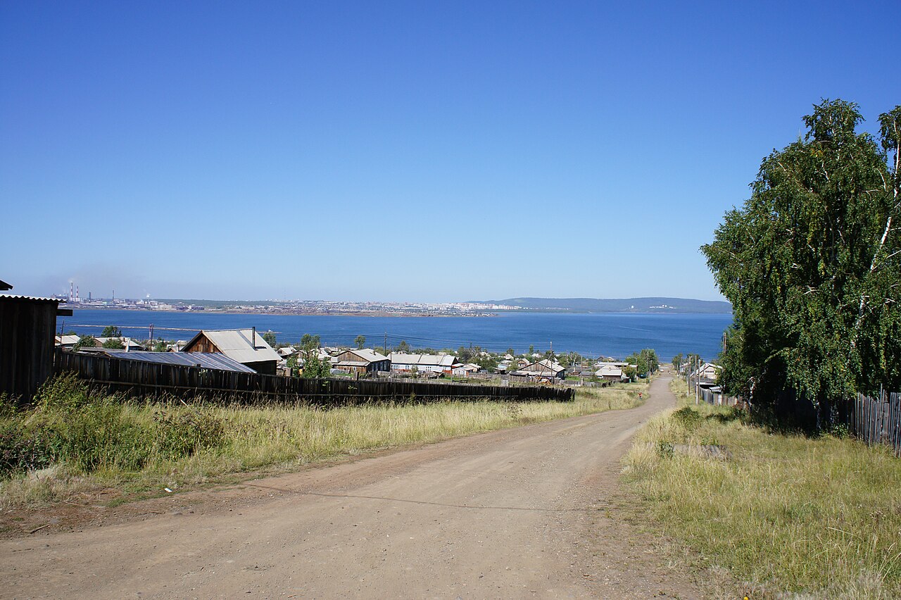
The view from Porozhsky shows the reservoir within an everyday urban landscape: timber houses, a street, greenery and broad water beyond. For residents, the sea is more than a destination for a special excursion. It is a horizon from a window, a walk to the shore and seasonal changes in a familiar setting.

The 2010 photograph is valuable precisely for its ordinary character. It depicts neither a ceremonial opening nor the entire hydraulic complex. Instead, private housing stands beside the vast body of water that became part of city life. One image cannot establish present access or the existence of an equipped beach; visitors should use current public approaches and respect differing access arrangements.

22 August 2010. A view from Porozhsky towards the reservoir, with wooden homes and a street in the foreground.
2010

Porozhsky and the Bratsk Sea

22 August 2010. A view from Porozhsky towards the reservoir, with wooden homes and a street in the foreground.

Сергей Чубуков · Wikimedia Commons
CC BY 3.0 · Original ↗

A sandy shore is not necessarily an equipped beach

Visitors come for space, forest, fishing and time beside the water. Sandy stretches look especially attractive in summer, but a photograph does not establish lifeguards, sanitary monitoring, road access or a safe entry. The same location changes with level and weather.

For a family outing, check whether the site is currently an equipped bathing place, how to reach it and which seasonal restrictions apply. Mobile coverage and a way to leave after rain also matter. Preparation helps match the shore to an actual trip rather than to somebody else's appealing photograph, taken in unknown conditions years earlier. The reservoir offers many landscapes, but their suitability depends on the day's circumstances.

Experiencing the scale from a boat

From a boat, elongated headlands, bay entrances and distances between shores become clearer. The experience can differ greatly from a short visit to a city beach. A route must nevertheless account for waves, fuel, shelter, communication and a return plan; losing sight of land changes preparation requirements.

Before booking an outing, confirm the boarding point, duration, actual route and weather-cancellation terms. Everyone needs a lifejacket, not just weaker swimmers. A description of a “quiet bay” does not guarantee a calm passage to it. Independent trips particularly depend on current warnings and local knowledge of shallows, submerged obstacles and changing depths.

Winter views from the shore

Snow, low sunlight and open space give the reservoir a different winter character. Seeing it does not require stepping onto the ice: shoreline viewpoints can reveal the scale and seasonal light without turning a walk into an ice crossing. Access roads and paths also change after snowfall and thaw.

Forecasts, sunset and the return journey matter especially at remote locations. Driving onto ice should only be considered in relation to an operating official crossing and its announced conditions, never merely because other tyre tracks exist. Emergency reports from spring show how quickly a familiar winter route loses reliability. A photograph of a level white surface cannot reveal currents, cracks or weakened areas.

Reading more than an attractive view

Archival village photographs, a modern shoreline view and a satellite image answer different questions. The first reconstruct buildings and people, the second records a season and viewpoint, and the third shows the shape of the whole reservoir. They should not be presented as interchangeable evidence without dates and captions.

This page gives a shooting year where the source supplies one; missing dates remain unknown rather than guessed. ESA's image is radar-based, and its colours should not be read as an ordinary view from an aircraft. Old and new Tangui occupy different sites. These distinctions let images document change while preserving both their visual appeal and historical meaning.

Researching a family's flooded village

A useful starting point is the settlement name, family surnames and approximate moving dates. Family photographs can then be compared with school records, village-council material, assessment documents and local histories. Spelling variants and changes in administrative boundaries matter.

Conversations with older relatives should record specific landmarks as well as the general flood story: neighbours, the house location, occupations and the new homestead. Scan the backs of photographs too, since captions often survive there. An unverified family account can be preserved as recollection without being presented as established fact. Combining personal archives with documentary records restores people and biographies to a village name on an old map.

Where to begin exploring the Bratsk Sea

A first introduction can combine three experiences: a shoreline view of the reservoir, the story of how the power station operates, and a visit to Angarskaya Derevnya. Together they offer scale, an engineering explanation and human dimensions. Check which side of the dam a viewpoint faces, and do not assume unrestricted access to the power station's working grounds.

A deeper journey can follow resettled communities, check water routes with the operator and explore relocation research. These are not one guaranteed day tour: distances are substantial and access and schedules change. The Bratsk Sea reveals itself gradually through maps and shores, scientific observations and family memories, and the present lives of places that once had to begin again.

Useful links

Bratskoye Vzmorye: the resort’s history ↗Zyaba: bay, beaches and dacha life ↗Bratsk HPP: history, specifications and visitors ↗Angarskaya Derevnya: the museum guide ↗Bratsk fortresses and their surviving towers ↗Bratsk districts: the city across its shores ↗Water-service schedules from the operator ↗Bratsk District: history and settlements ↗

Sources & further reading

Checked: 19 October 2026. Historical documents, recollections and modern observations are dated separately. Water-quality findings concern 2025; the satellite bloom bulletin covers 24–29 June 2026. Image publication dates are not presented as exact shooting dates. Confirm schedules, water conditions and access restrictions before travelling.