← Explore the cityBRATSK / PEOPLE & PLACES

The Bratsk forts.

From the first outpost at Padun Rapids to two towers saved from inundation: the changing sites, people, buildings and discoveries behind Bratsk Ostrog.

24 CHAPTERS / ABOUT 13 MIN READ
1631

foundation of the first fort

3

principal historical sites

1685

date of the surviving towers in the 2026 study

2

surviving towers in two museums

Article contents

Three sites, successive forts, two towers

Bratsk Ostrog is often imagined as a single wooden fortress that stood unchanged until the hydroelectric project. Its name actually covers successive sites, replacement structures and centuries of repair. Banks, defences, inhabitants and the garrison’s purpose all changed. The surviving towers belong to a later chapter.

Three principal geographical stages help organise the story: a fort near Padun Rapids, another on the right bank of the Oka, and the settlement on its left bank. Each could include rebuilt walls, repositioned towers and replacement logs. “Third fort” therefore describes a location and historical stage, rather than an untouched third set of timbers.

Modern Bratsk inherited the settlement’s name. The original submerged site, the museum reconstruction and the two surviving towers are distinct places. Their connections form the subject of this article.
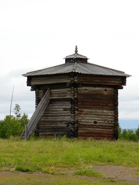
The southwest tower at Angara Village. A 2026 study dates the surviving towers to 1685, revising the traditional museum date of 1654.
б/д · undated

An original Bratsk Ostrog tower

The southwest tower at Angara Village. A 2026 study dates the surviving towers to 1685, revising the traditional museum date of 1654.

Фотограф не указан / Photographer not named · Братский городской объединённый музей / Bratsk City Museum
© Bratsk City Museum · официальная музейная публикация / official museum publication · Original ↗
A land already inhabited

Russian detachments entered an inhabited Angara region. Buryat communities lived along the Angara and Oka, while Evenki people, called Tungus in Russian documents, occupied the wider taiga. Herding, hunting, fishing, trade and knowledge of river routes predated the fortress.

Bratsk derives from Russian terms for Buryats: braty and bratskiye lyudi. Its modern sound suggests brotherhood, but the historical name referred to people already living here. Records of the “Bratsk land” describe encounters with communities rather than an empty future map.

The founding therefore had different meanings. For the expanding Russian administration it established authority and a tribute station. For local inhabitants an armed garrison brought demands, disruption and danger. Both perspectives are essential to understanding subsequent conflict.

The Angara was the road

Seventeenth-century expansion followed rivers. Boats carried people, arms, food and collected furs. Upstream travel was arduous, and rapids could turn a short stretch into a major obstacle. Fort locations depended on this river geography.

Yeniseysk became the starting point for expeditions up the Angara, also called the Upper Tunguska in contemporary sources. The administration sought information about inhabitants, fur resources, farming land and tribute collection.

Early accounts name Panteley Pyanda, Maxim Perfilyev and Pyotr Beketov. An expedition, a temporary winter station and an established fort are different events, however. An early journey date cannot automatically become Bratsk’s foundation date. The settlement emerged from successive reconnaissance missions and encounters rather than one ceremonial occasion.

Perfilyev and Beketov: the founder question

Maxim Perfilyev is associated with the fort’s foundation in 1631. Pyotr Beketov appears nearby in the documentary record: he travelled along the Angara earlier and later served at Bratsk. Some accounts consequently credited him with a first fort in the late 1620s.

Historian A. A. Pavlov compares Beketov’s later petitions with administrative and tribute records. He argues that evidence of travel and tribute collection does not establish that Beketov built the first Bratsk fort. That interpretation must be distinguished from simply repeating a serviceman’s retrospective list of achievements.

The debate illustrates historical method. Participants could describe their achievements decades later; researchers test those statements against records with other origins. The principal accepted foundation year remains 1631.

The first fort: Padun Rapids

Perfilyev’s first fort is associated with the Angara’s right bank near Padun Rapids. Far from Yeniseysk, it stood in territory the new administration did not securely control. Its immediate purposes were survival, winter accommodation and support for tribute expeditions.

It should not be imagined as today’s extensive museum ensemble with a church and village street. The first fort was much smaller. Documentary references to strong defences do not supply a complete architectural plan or precise tower dimensions.

The city chronicle traditionally marks 18 June 1631. Scholarly accounts discuss other calendar points for completion and the detachment’s return. The year is the central foundation date here; the modern commemorative day is not presented as a proven first-log ceremony.

The fort is destroyed

Holding a small outpost amid hostile communities proved difficult. The first fort was destroyed in 1635. The chronicle preserves a report of the garrison’s losses and the burning, naming Buryat leaders involved.

That event ended the first fortress. The next stage was not merely a replacement roof at the same spot: it concerned a different location by the Oka. No continuous chain of surviving walls connects the first fort to a present museum tower.

The brief record belongs to a conflict over subordination and tribute. Russian detachments used armed force, local communities resisted and small garrisons were vulnerable. These relationships explain both the need for defences and the changing sites.

The second fort: the Oka’s right bank

The next stage concerns Nikolai Radukovsky, also recorded as Radunovsky. Following the 1635 expedition, a new fort appeared on the Oka’s right bank. The city chronicle dates construction to 1636; 1635 also occurs in literature in connection with the expedition.

The location brought the garrison closer to Buryat settlements and agricultural land. Control concerned people, tribute, fisheries and access to resources rather than an abstract line on a map. Life gradually extended beyond the yearly rotation of servicemen.

Much later researchers gathered local testimony and compared traditions with terrain and building traces. Oral memory after several centuries requires checking, but its combination with written evidence helped distinguish this right-bank site from the later Bratskoye village.

Ivan Pokhabov rebuilds

Ivan Pokhabov arrived in 1644. The chronicle reports a new enclosure around the old fort, with ditches and defensive obstacles. The record describes the earlier structure as small and dilapidated.

A wooden fortress required continual maintenance. Lower log courses suffered from damp; palisade posts decayed in the ground; heating and open flames created fire risks. “Built” did not mean safe to leave untouched for a century.

This episode also distinguishes relocation from rebuilding. New walls could surround an older enclosure at the same site and alter its size without creating a newly named settlement. The physical fort changed even when its administrative identity remained.

A garrison needs grain

Weapons alone could not sustain the fort. Its inhabitants needed flour, grain, fish, fuel, clothing, tools and skilled repair. Long-distance deliveries were slow and unreliable, making local agriculture a recurring concern in mid-century documents.

The chronicle records the 1649 flood destroying crops, searches for suitable land and attempts to settle peasants. A farming district could provide reliable supplies. Farmers, townspeople and craftspeople appear alongside servicemen; a blacksmith could be as essential as a guard.

These dependencies helped turn an outpost into a settlement. Bratsk became a working economic centre as well as an expedition base. Barns, stoves and agricultural tools belong to the fort’s history because they sustained its daily life.

Dmitry Firsov and the third site

In spring 1654 Dmitry Firsov moved the fort to the Oka’s left bank, where it became the nucleus of Bratskoye village. Defence, relations with tribute-paying communities and farmers, and competition over revenue all contributed to the move.

Firsov’s report describes four towers, a gateway with a chapel and a new storehouse. Three towers had rooms beneath them; the fourth was empty. Servicemen, peasants and other settlers took part in construction.

The record gives a tangible picture of an enclosure combining defence, accommodation, storage and religious life. It does not establish that the surviving timbers themselves date to 1654. The fort underwent repeated rebuilding afterwards.

Palisade, tower and projecting fighting gallery

A tyn was a wall of upright logs, restricting access and forcing attackers to cross an obstacle under defensive fire. Ditches and further obstacles could strengthen a small garrison. The system depended on several elements working together.

Corner towers provided observation and covered adjacent wall sections. The projecting upper fighting level, or oblam, enlarged the defensive space and enabled action close to the tower’s base. The overhanging roof protected both timber and defenders from precipitation.

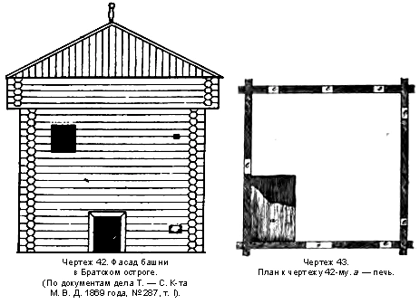
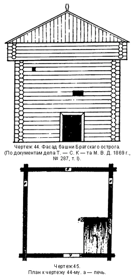
Early survey drawings show log proportions, openings and the differences between a tower and a domestic cabin. They record the monument after generations of repair, however, rather than preserve an unchanged design for the first 1631 fort.

Figure 42–43 in N. V. Sultanov’s book, published in 1907. This is the publication date, not the construction date; a 2026 study revises the tower dating given in the old text.
1907

Northwest tower: elevation and plan

Figure 42–43 in N. V. Sultanov’s book, published in 1907. This is the publication date, not the construction date; a 2026 study revises the tower dating given in the old text.

Н. В. Султанов / N. V. Sultanov · Историческое издание 1907 года / Historical publication, 1907
Общественное достояние / Public domain · Original ↗

Figure 44–45 in N. V. Sultanov’s book, published in 1907. This is the publication date, not the construction date; a 2026 study revises the tower dating given in the old text.
1907

Southwest tower: elevation and plan

Figure 44–45 in N. V. Sultanov’s book, published in 1907. This is the publication date, not the construction date; a 2026 study revises the tower dating given in the old text.

Н. В. Султанов / N. V. Sultanov · Историческое издание 1907 года / Historical publication, 1907
Общественное достояние / Public domain · Original ↗

Inside: administration, stores and hostages

The enclosure contained the working spaces of a small administrative centre. Its official received reports, stored collected goods and organised servicemen’s journeys. A state storehouse was part of that administrative economy.

Yasak, principally fur tribute, connected the fort with local inhabitants and distant authorities. The system also used amanats: hostages held as guarantees of compliance. An amanat house appears in Avvakum’s account of his imprisonment at Bratsk.

Terms such as settlement and allegiance can obscure these practical relationships. Asking who demanded tribute, collected it, lost freedom or supplied food reveals the fort as an institution of power as well as a distinctive wooden silhouette.

Avvakum: a winter in captivity

Archpriest Avvakum reached Bratsk while travelling to Dauria with governor Afanasy Pashkov’s expedition. He was imprisoned here during 1656–1657. His autobiographical Life and the documents assembled by the Russian archives offer personal and administrative perspectives.

He recalled cold, hunger and transfer from a tower to a heated building occupied by hostages. His account is a powerful individual voice in early Bratsk history: an account of religious ordeal that also records conditions of captivity and fort life.

A tradition links his imprisonment to the tower now in Kolomenskoye. The new 1685 dating prevents identification of its present log structure with his 1656 prison. An authentic historical episode does not establish the identity of the surviving timbers.

A fortress continually changing

The climate did not preserve timber automatically. Walls and towers decayed and needed dismantling and reassembly. Late-seventeenth-century documents report poor condition and renewed construction. Moving towers or replacing walls could alter the enclosure’s perimeter.

The history therefore continued after the 1654 relocation. A settlement’s foundation, a replacement wall and the felling date of one tower’s logs answer different questions. Builders might reuse material or replace only part of a frame.

Documents and fabric must be studied together. Written orders describe intentions and reported work; the structure preserves joints, alterations and replacement courses. Their comparison produces a more complex building history than a single date on a sign.

Reading Remezov’s drawing

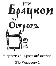
The image reproduced by N. V. Sultanov after Semyon Remezov shows Bratsk as an enclosed quadrangle with towers. It preserves an early cartographic representation of the fortified settlement.

It is not a satellite image or a modern measured plan. Symbols, labels and proportions are conventional. Their dimensions cannot simply be converted into metres or compass directions. Reconstruction requires comparison with inventories, surveys and archaeology.

Its value lies in preserving an image of Bratsk when an enclosure still defined the settlement. Beside a later photograph of an isolated tower, the drawing helps recover the idea of a complete fortified ensemble.

Figure 46 in N. V. Sultanov’s book, published in 1907. This is the publication date, not the construction date; a 2026 study revises the tower dating given in the old text.
1907

Bratsk Ostrog in an early schematic drawing

Figure 46 in N. V. Sultanov’s book, published in 1907. This is the publication date, not the construction date; a 2026 study revises the tower dating given in the old text.

С. У. Ремезов / S. U. Remezov; публикация Н. В. Султанова / published by N. V. Sultanov · Историческое издание 1907 года / Historical publication, 1907
Общественное достояние / Public domain · Original ↗

Why reference books disagree

Popular accounts include a 1648 relocation, whereas Pavlov identifies the right-bank Oka fort of 1636. These should not automatically be combined into a further proven fortress: they belong to different historical reconstructions.

Earlier scholars worked with the records available to them. Later research introduced other documents and revised the sequence. Expedition, wintering and completion could fall in different years, while the seventeenth-century calendar complicates conversion.

This article follows Pavlov’s three-site framework while acknowledging the alternative tradition. Older books remain valuable for surveys and observations even where subsequent scholarship revises their chronology.

The fort becomes a village

As frontiers and transport routes changed, the original military role diminished. Farms, church life and administrative activity continued around the former enclosure. The name outlasted parts of its walls.

The eighteenth-century chronicle places Bratsk within the history of its district, economy and population. This slower development explains the continuity of the later village. Ostrog could increasingly refer to a place rather than a functioning fortress.

By the early twentieth century two towers survived among established village buildings. Their meaning was changing from military infrastructure to historic monument, well before the modern museum existed.

Towers among village homes

Accounts of old Bratskoye place the monument within ordinary village life. Sultanov describes two towers at the corners of the churchyard: remnants of a fort rather than a complete surviving defensive ensemble.

They did not yet have a modern museum’s conservation system. Visitors surveyed, drew and measured them, debating repairs. Familiar landmarks for residents could appear to an architect as rare evidence of a disappearing building tradition.

Early measured drawings consequently matter. They preserve details before dismantling, transport and later restoration. An opening, a joint or an altered wall can help distinguish original material from subsequent work. Small details become evidence within the larger history.

Excavation before the water

The hydroelectric project placed the old fort site within the future reservoir. Archaeologists and conservators had to examine the ground and decide the surviving structures’ fate before inundation.

A. V. Nikitin excavated in 1957 and 1959. Wall traces, construction remains and finds supplied evidence unavailable from the standing towers alone. Parallel enclosure traces, for example, informed discussion of changes to the fortress perimeter.

The work faced a deadline. Rising water would prevent ordinary access, making records, plans, find locations and photographs as important as recovered objects. Those documents allow researchers to revisit a site that visitors can no longer walk across.

Dismantling in order to preserve

Relocation was chosen for both towers. A log structure can be dismantled course by course, marked and reassembled on another foundation. Accurate surveys and careful handling are essential to preserve the order of its components.

The northwestern tower was moved to Kolomenskoye in 1959. The southwestern tower remained in Bratsk and later entered Angara Village. Two parts of one historic ensemble thus reached distant museum settings, separated from the submerged original site.

The move saved structures while changing their surroundings. In Moscow the tower joined a collection of wooden architecture; in Bratsk it linked fort and village history. Reconstructing the original settlement mentally requires reconnecting these separated pieces with its walls and river.

26 July 2011. The relocated tower in Kolomenskoye, Moscow. A modern photograph of a historic structure.
2011

A tower of Bratsk Ostrog

26 July 2011. The relocated tower in Kolomenskoye, Moscow. A modern photograph of a historic structure.

А.Савин, Википедия / A.Savin, Wikipedia · Wikimedia Commons
CC BY-SA 3.0 · Original ↗

1685: the evidence of tree rings

Dendrochronology matches tree-ring sequences in building timber with dated reference chronologies. Where suitable outer rings survive, it can establish felling dates and independently test a building’s history.

A 2010 study challenged the southwestern tower’s conventional 1654 dating. Research published in Russian Archaeology in 2026 examined both surviving towers. Its authors date construction to 1685 and reject the hypothesis that the two were built at different times.

The result revises the surviving structures’ age without cancelling the fort’s 1631 foundation or 1654 relocation. The history of a site and the date of its surviving buildings are different questions.

Where to see the surviving towers

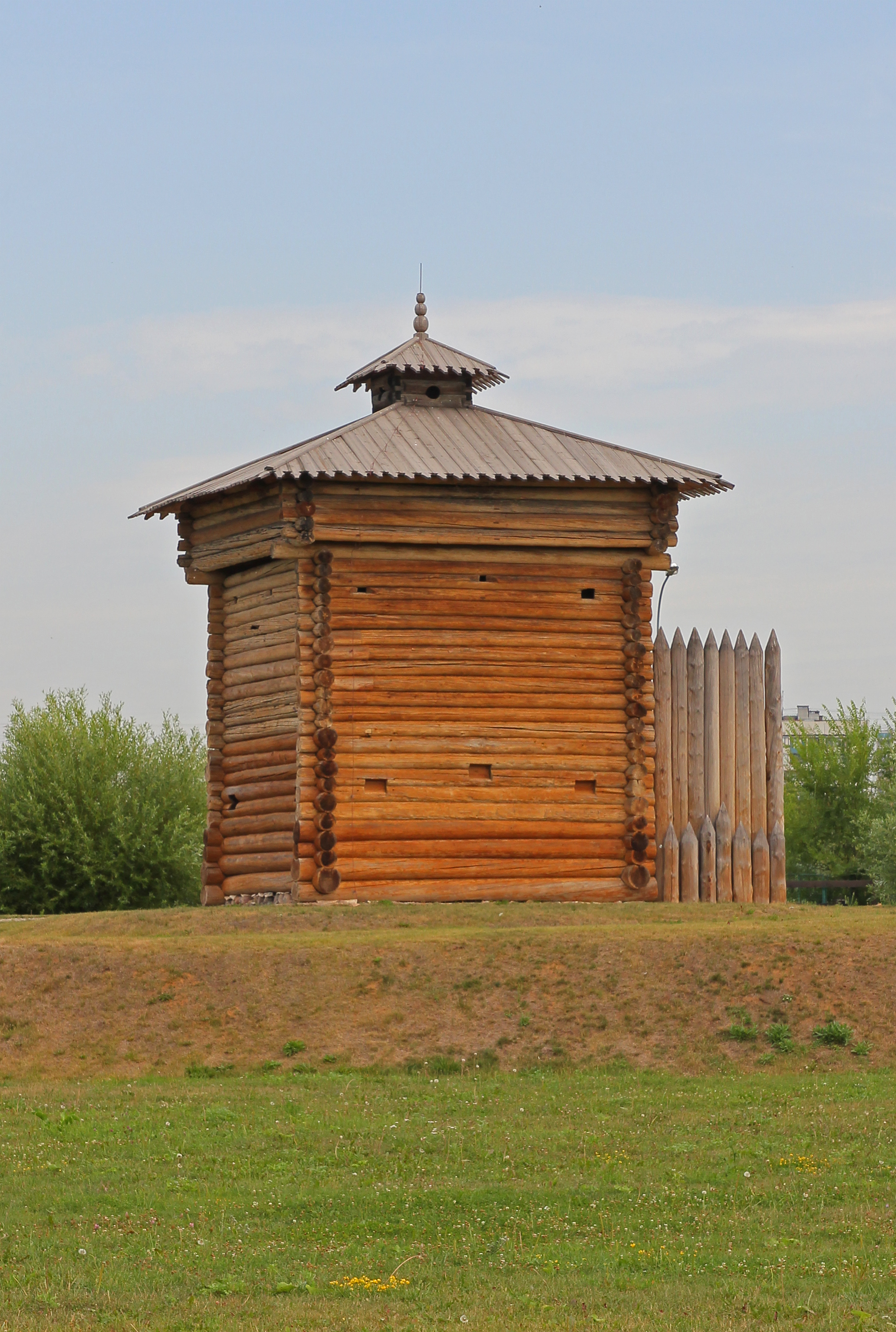
The southwestern tower stands in Bratsk’s Oktyabr Leonov Angara Village museum. Its local setting recalls the Angara history, although it is a museum location rather than the original Oka bank.

The northwestern tower is in Moscow’s Kolomenskoye, within its wooden architecture collection. Exterior details can be compared with other relocated monuments; museum arrangements determine access.

Comparing the two is revealing. Differences in construction details do not necessarily imply different ages, one of the questions tested by recent research. A visitor seeing only one tower should remember the other: the historic ensemble survives in separated form.

The southwest tower at Angara Village. A 2026 study dates the surviving towers to 1685, revising the traditional museum date of 1654.
б/д · undated

An original Bratsk Ostrog tower

The southwest tower at Angara Village. A 2026 study dates the surviving towers to 1685, revising the traditional museum date of 1654.

Фотограф не указан / Photographer not named · Братский городской объединённый музей / Bratsk City Museum
© Bratsk City Museum · официальная музейная публикация / official museum publication · Original ↗
Restoring the idea of an enclosure

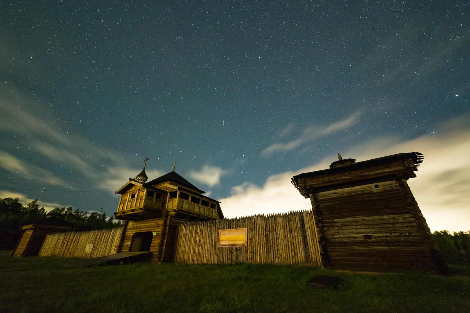
Since 2012 Angara Village has developed a reconstructed fort ensemble. The official description includes towers, a gateway chapel, palisade and internal structures, helping visitors understand an enclosure rather than an isolated tower.

Original monuments and reconstructions offer different kinds of evidence. Old logs retain their material history; a reconstructed wall conveys scale, enclosure and spatial relationships. Reconstruction explains sources but does not itself become a seventeenth-century document.

Museum views and early surveys are identified separately in this article, allowing comparison between historical record, surviving fabric and modern interpretation.

The modern fort reconstruction at Angara Village demonstrates the layout of an outpost; it is not an intact seventeenth-century enclosure.
б/д · undated

The fort in its museum setting

The modern fort reconstruction at Angara Village demonstrates the layout of an outpost; it is not an intact seventeenth-century enclosure.

Фотограф не указан / Photographer not named · Братский городской объединённый музей / Bratsk City Museum
© Bratsk City Museum · официальная музейная публикация / official museum publication · Original ↗
Continuing the investigation

Three kinds of reading complement one another. The city chronicle supplies a sequence; Pavlov examines disputed sites and relocations; measured drawings and dendrochronology test the monuments’ fabric and age.

Publication dates matter. Sultanov recorded an early-twentieth-century state of knowledge, before the 2026 dating. His drawings and observations retain value even where conclusions change. A scientific correction does not invalidate every part of an earlier work.

Questions remain about precise early locations, surrounding settlement, economic relationships and Indigenous perspectives. The separate Angara Village article continues the story through rescue expeditions, relocated buildings and the preservation of everyday life.

Useful links

Read the Angara Village feature ↗Wooden architecture at Kolomenskoye ↗Bratsk HPP and reservoir history ↗

Sources & further reading

Checked: 2026-10-19. The main chronology ends in 1991; later events and photographs carry their own dates.